
Сделать пожертвование
Топографическая карта Roseburg
Нажмите на карту, чтобы отобразить высоту.
Сделать пожертвование
Roseburg
Roseburg's elevation is approximately 500 feet (150 m). Its highest point is Mount Nebo, a 1,200-foot (370 m) hill to the west of Interstate 5. Through the 1980s, it was known for its band of 10-20 feral angora goats. Residents said they could predict the weather by watching where the goats were on the mountain; if they were high, the weather would be good. If rain was pending, the goats moved to lower levels. Because the goats wandered across the freeway for grazing, they were a risk to traffic. In the 1980s, they were rounded up and placed for adoption.
Сделать пожертвование
Об этой карте
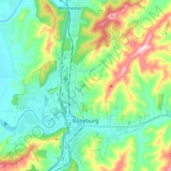
Название: Топографическая карта Roseburg, высота, рельеф.
Местонахождение: Roseburg, Douglas County, Oregon, United States (43.19052 -123.40198 43.28152 -123.27021)
Средняя высота: 239 м
Минимальная высота: 116 м
Максимальная высота: 546 м
Сделать пожертвование
Другие топографические карты
Нажмите на карту, чтобы просмотреть ее топографию, ее высоту и ее рельеф.
Сделать пожертвование
Сделать пожертвование
Сделать пожертвование