
Сделать пожертвование
Топографическая карта Virgin
Нажмите на карту, чтобы отобразить высоту.
Сделать пожертвование
Virgin
Virgin is a town in Washington County, Utah, United States. The population was 670 at the 2020 census. The first settlement at Virgin was made in 1858. It is located along the Virgin River (for which it is named), and not far from Zion National Park. The elevation is 3,606 feet (1,099 m). It lies on State Route 9.
Сделать пожертвование
Об этой карте
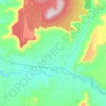
Название: Топографическая карта Virgin, высота, рельеф.
Местонахождение: Virgin, Washington County, Utah, United States (37.17063 -113.25585 37.26243 -113.14567)
Средняя высота: 1 251 м
Минимальная высота: 1 003 м
Максимальная высота: 1 758 м
Сделать пожертвование
Другие топографические карты
Нажмите на карту, чтобы просмотреть ее топографию, ее высоту и ее рельеф.
Сделать пожертвование
Zion Canyon
United States > Utah > Washington County
Geologically Zion Canyon is part of the Navajo sandstone Colorado Plateau, which contained many joints and cracks when first uplifted, one of which was cut by the North Fork of the Virgin River to become Zion Canyon. The river was the largest force in cutting the canyon, mostly by flash floods, as the average…
Средняя высота: 1 821 м
Сделать пожертвование
Angels Landing
United States > Utah > Washington County
The trail to Angels Landing is 2.5 miles (4.0 km) long with an approximate 1,500 feet (460 m) elevation gain. The hike is rated as a class 3 difficulty based on the Yosemite Decimal System. It begins at the Grotto drop-off point on the park's shuttle system, which operates from early spring through late fall.…
Средняя высота: 1 695 м