
Топографическая карта Lake Harris
Интерактивная карта
Нажмите на карту, чтобы отобразить высоту.
Lake Harris
Lake Harris' depth is much greater than Lake Okeechobee to the south, with many deeper holes and ledges. The lake is surrounded by sandhills and cypress trees, part of the Central Florida Ridge. This region has the highest elevations in central Florida, reaching 312 feet (95 m) above sea level. Compared to the rest of Florida, which is relatively flat, it is quite hilly.
Об этой карте
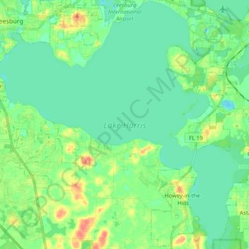
Название: Топографическая карта Lake Harris, высота, рельеф.
Местонахождение: Lake Harris, North Canal Drive, Yalaha, Lake County, Florida, 34797, United States of America (28.69061 -81.88751 28.82165 -81.73982)
Средняя высота: 25 м
Минимальная высота: 11 м
Максимальная высота: 59 м