
Сделать пожертвование
Топографическая карта Donges Bay
Нажмите на карту, чтобы отобразить высоту.
Сделать пожертвование
Об этой карте
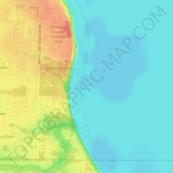
Название: Топографическая карта Donges Bay, высота, рельеф.
Местонахождение: Donges Bay, Ozaukee County, Wisconsin, 53092, United States (43.20357 -87.89430 43.20367 -87.89420)
Средняя высота: 190 м
Минимальная высота: 171 м
Максимальная высота: 225 м
Сделать пожертвование
Другие топографические карты
Нажмите на карту, чтобы просмотреть ее топографию, ее высоту и ее рельеф.
Port Washington
United States > Wisconsin > Ozaukee County
The city is located on the western shore of Lake Michigan. In northern and southern parts of the city, the coastline is characterized by clay bluffs ranging from 80 feet (24 meters) to 130 feet (40 meters) in height with deep ravines where streams flow into the lake. Clay bluffs are a geological formation…
Средняя высота: 205 м
Сделать пожертвование
Port Washington
United States > Wisconsin > Ozaukee County
The city is located on the western shore of Lake Michigan. In northern and southern parts of the city, the coastline is characterized by clay bluffs ranging from 80 feet (24 meters) to 130 feet (40 meters) in height with deep ravines where streams flow into the lake. Clay bluffs are a geological formation…
Средняя высота: 201 м
Сделать пожертвование
Сделать пожертвование