
Спасибо за поддержку этого сайта ❤️
Сделать пожертвование
Сделать пожертвование
Топографическая карта Maicao
Нажмите на карту, чтобы отобразить высоту.
Спасибо за поддержку этого сайта ❤️
Сделать пожертвование
Сделать пожертвование
Maicao
The municipality of Maicao borders to the north with the municipalities of Uribia and Manaure; to the east with the Venezuela; to the south with the municipality of Albania and to the west with the municipality of Riohacha covering a total area of 1,782 km2 and at altitude over sea level of 52 m.
Спасибо за поддержку этого сайта ❤️
Сделать пожертвование
Сделать пожертвование
Об этой карте
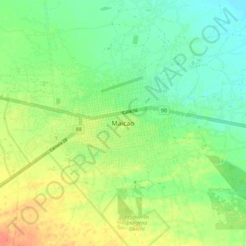
Название: Топографическая карта Maicao, высота, рельеф.
Местонахождение: Maicao, La Guajira, RAP Caribe, 442001, Colombia (11.33731 -72.27876 11.41731 -72.19876)
Средняя высота: 51 м
Минимальная высота: 34 м
Максимальная высота: 73 м
Спасибо за поддержку этого сайта ❤️
Сделать пожертвование
Сделать пожертвование