
Сделать пожертвование
Топографическая карта Coalville
Нажмите на карту, чтобы отобразить высоту.
Сделать пожертвование
Coalville
Coalville has a high-altitude, warm-summer humid continental climate (Köppen Dfb), characterized by extreme diurnal temperature ranges that range from extremely cold winter nights to hot afternoons in the summer. However, the high altitude and low humidity mean that mornings in the summer remain very cool, and frosts have occasionally occurred—even in July. Precipitation is moderate throughout the year, though with a minimum in summer, and snow accumulation is generally heavy due to the very cold nights between November and March, with a median of 60.1 inches (1.53 m) for the year.
Сделать пожертвование
Об этой карте
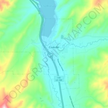
Название: Топографическая карта Coalville, высота, рельеф.
Местонахождение: Coalville, Summit County, Utah, United States (40.89002 -111.47093 40.93640 -111.37770)
Средняя высота: 1 825 м
Минимальная высота: 1 683 м
Максимальная высота: 2 257 м
Сделать пожертвование
Другие топографические карты
Нажмите на карту, чтобы просмотреть ее топографию, ее высоту и ее рельеф.
Сделать пожертвование
Сделать пожертвование
Сделать пожертвование