
Топографическая карта Addlestone
Нажмите на карту, чтобы отобразить высоту.
Addlestone
Elevations range between 11 metres (36 ft) and 40 metres (130 ft). The maximum is on Row Hill recreation ground, Row Town, Addlestone; a ridge that continues to the northwest of Row Town where it is known as Ongar/Spinney Hill, where Great Grove Farm in its centre also reaches this height; the minimum is by the Thames and along the Woburn Park Stream which is the main distributary of The Bourne the main waterway of the village, a stream rising as the Windle Brook in Windlesham cutting a shallow ravine, flowing past the McLaren Technology Centre and Woodham then passing to the east of the village.
Об этой карте
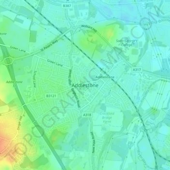
Название: Топографическая карта Addlestone, высота, рельеф.
Местонахождение: Addlestone, Borough of Runnymede, Surrey, England, United Kingdom (51.36185 -0.50737 51.38044 -0.47211)
Средняя высота: 18 м
Минимальная высота: 8 м
Максимальная высота: 45 м
Другие топографические карты
Нажмите на карту, чтобы просмотреть ее топографию, ее высоту и ее рельеф.
Cooper's Hill Slopes
United Kingdom > England > Surrey > Borough of Runnymede > Englefield Green
Средняя высота: 38 м
Chertsey
United Kingdom > England > Surrey > Borough of Runnymede
Samuel Lewis devotes one of his longest entries to the small town in his 1848 topographical guide to England.
Средняя высота: 22 м
Egham Wick
United Kingdom > England > Surrey > Borough of Runnymede > Englefield Green
Средняя высота: 55 м
Lyn Mushroom Farm
United Kingdom > England > Surrey > Borough of Runnymede > Lyne
Средняя высота: 39 м
Chertsey
United Kingdom > England > Surrey > Borough of Runnymede
Samuel Lewis devotes one of his longest entries to the small town in his 1848 topographical guide to England.
Средняя высота: 22 м