
Сделать пожертвование
Топографическая карта Halifax
Нажмите на карту, чтобы отобразить высоту.
Сделать пожертвование
Halifax
Topographically, Halifax is located in the south-eastern corner of the moorland region called the South Pennines. Halifax is situated about 4 miles (6 km) from the M62 motorway, close to Bradford and Huddersfield. The A641 road links the town with Brighouse, Bradford and Huddersfield. The Hebble Brook joins the River Calder at Salterhebble.
Сделать пожертвование
Об этой карте
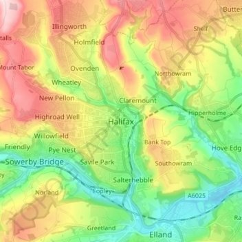
Название: Топографическая карта Halifax, высота, рельеф.
Местонахождение: Halifax, Calderdale, West Yorkshire, England, HX1 1TH, United Kingdom (53.68292 -1.90049 53.76292 -1.82049)
Средняя высота: 195 м
Минимальная высота: 56 м
Максимальная высота: 389 м
Сделать пожертвование
Другие топографические карты
Нажмите на карту, чтобы просмотреть ее топографию, ее высоту и ее рельеф.
Todmorden
United Kingdom > England > Calderdale > Lydgate
Todmorden Town Hall, which was designed in the Neo-Classical style, dominates the centre of the town. The building straddles the Walsden Water, a tributary of the River Calder, and was situated in both Lancashire and Yorkshire until the administrative county boundary was moved on 1 January 1888. Designed by…
Средняя высота: 311 м
Сделать пожертвование
Calder & Hebble Navigation Halifax Cut
United Kingdom > England > Calderdale > Skircoat Green
Средняя высота: 136 м
Ragby Plantation
United Kingdom > England > Calderdale > Todmorden > Walsden > Bottoms
Средняя высота: 293 м
Сделать пожертвование
Gaddings Dam
United Kingdom > England > Calderdale > Todmorden > Walsden
Gaddings Dam is a locally owned reservoir near to Todmorden in West Yorkshire, England. The dam was built to power water mills in the Todmorden area, being superseded by steam power and left redundant. It is notable for having a sandy beach at the north-eastern side which attracts people to it during the…
Средняя высота: 283 м
Сделать пожертвование
Todmorden
United Kingdom > England > Calderdale
Todmorden Town Hall, which was designed in the Neo-Classical style, dominates the centre of the town. The building straddles the Walsden Water, a tributary of the River Calder, and was situated in both Lancashire and Yorkshire until the administrative county boundary was moved on 1 January 1888. Designed by…
Средняя высота: 311 м