
Сделать пожертвование
Топографическая карта Magglingen
Нажмите на карту, чтобы отобразить высоту.
Сделать пожертвование
Об этой карте
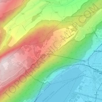
Название: Топографическая карта Magglingen, высота, рельеф.
Местонахождение: Magglingen, Evilard, Biel/Bienne administrative district, Seeland administrative region, Bern, 2532, Switzerland (47.12025 7.19588 47.16025 7.23588)
Средняя высота: 705 м
Минимальная высота: 424 м
Максимальная высота: 1 086 м
Сделать пожертвование
Другие топографические карты
Нажмите на карту, чтобы просмотреть ее топографию, ее высоту и ее рельеф.
Biel/Bienne
Switzerland > Bern > Biel/Bienne administrative district
One funicular railways leads to the national sports center of Magglingen/Macolin on the 500 metres (1,600 ft) higher Jura mountain in the west, and the other, the Bienne-Evilard Funicular, to the city hospital and to neighbouring municipality Evilard to northwest, both above the town on the eastern range of…
Средняя высота: 655 м
Evilard
Switzerland > Bern > Biel/Bienne administrative district
The municipality reaches to the height of the anticline of Montagen de Macolin. It includes the town of Evilard, which is surrounded by Malvaux (German: Malewagwald, up to 765 m (2,510 ft) altitude). To the southwest, the municipality reaches in a narrow strip over the Magglingen to the peak of the…
Средняя высота: 583 м
Сделать пожертвование