
Сделать пожертвование
Топографическая карта Castro de Rei
Нажмите на карту, чтобы отобразить высоту.
Сделать пожертвование
Castro de Rei
Castro de Rei is located in the comarca of the Terra Cha. This factor determines the most of their socioeconomic characteristics. Its average altitude is between 400 and 500 meters. In the east the terrain becomes more rugged due to its proximity to the eastern mountains. The elevation of the Montes dos Millares is 620 meters and the Pedras Albas has an elevation of 619 meters Pedras Albas. The Minho river and several of its tributaries irrigate the lands. The Minho runs through the municipality and derives secondary manifolds, which are Azúmara, the Lea, and Anllo. Climatically, Castro de Rei has a temperate climate with abundant rainfall in the winter months. The region is characterized by its plains and its vast wetlands, home to waterfowl and large communities of amphibians. Associated with these wetlands appears a landscape mosaic, ecologically rich with color and an ample variety of habitats: grasslands, crops, forests, heath and rushes. The functional organization of the territory follows a monocentric structure with three main comarcas: Vilalba, Guitiriz and Castro de Rei. Castro de Rei has three mountain ranges.
Сделать пожертвование
Об этой карте
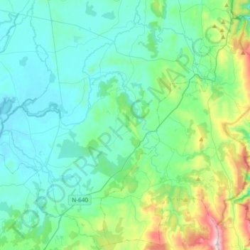
Название: Топографическая карта Castro de Rei, высота, рельеф.
Местонахождение: Castro de Rei, Terra Chá, Lugo, Galicia, Spain (43.06769 -7.56114 43.28280 -7.34695)
Средняя высота: 505 м
Минимальная высота: 388 м
Максимальная высота: 1 023 м
Сделать пожертвование
Другие топографические карты
Нажмите на карту, чтобы просмотреть ее топографию, ее высоту и ее рельеф.