
Топографическая карта 12200
Интерактивная карта
Нажмите на карту, чтобы отобразить высоту.
Об этой карте
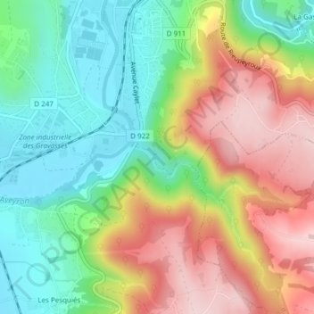
Название: Топографическая карта 12200, высота, рельеф.
Местонахождение: 12200, Villefranche-de-Rouergue, Aveyron, Occitanie, France métropolitaine, France (44.33209 2.03524 44.33219 2.03534)
Средняя высота: 360 м
Минимальная высота: 241 м
Максимальная высота: 516 м
Другие топографические карты
Нажмите на карту, чтобы просмотреть ее топографию, ее высоту и ее рельеф.
Les Imberts Hauts
France > Occitanie > Aveyron > Villefranche-de-Rouergue
Les Imberts Hauts, Villefranche-de-Rouergue, Aveyron, Occitanie, France métropolitaine, 12200, France
Средняя высота: 325 м
Mas de Bonnet
France > Occitanie > Aveyron > Villefranche-de-Rouergue
Mas de Bonnet, Villefranche-de-Rouergue, Aveyron, Occitanie, France métropolitaine, 12200, France
Средняя высота: 322 м
Les Ruelles
France > Occitanie > Aveyron > Villefranche-de-Rouergue
Les Ruelles, Villefranche-de-Rouergue, Aveyron, Occitanie, France métropolitaine, 12200, France
Средняя высота: 327 м
Mas de Vernhet
France > Occitanie > Aveyron > Villefranche-de-Rouergue
Mas de Vernhet, Villefranche-de-Rouergue, Aveyron, Occitanie, France métropolitaine, 12200, France
Средняя высота: 340 м
Mas de Rivals
France > Occitanie > Aveyron > Villefranche-de-Rouergue
Mas de Rivals, Villefranche-de-Rouergue, Aveyron, Occitanie, France métropolitaine, 12200, France
Средняя высота: 326 м