
Сделать пожертвование
Топографическая карта Wisconsin
Нажмите на карту, чтобы отобразить высоту.
Сделать пожертвование
Wisconsin
Wisconsin's topography is characterized by a diverse landscape shaped by glacial activity, resulting in a mixture of rolling hills, flat plains, and numerous lakes. The state’s highest point is Timms Hill, reaching an elevation of 1,952 feet (595 meters), while its lowest point is the shore of Lake Michigan at approximately 579 feet (176 meters). Notably, the region features over 15,000 lakes and several prominent landforms, including the Baraboo Hills and the Kettle Moraine, creating a varied and picturesque terrain.
Сделать пожертвование
Об этой карте
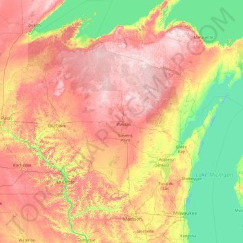
Название: Топографическая карта Wisconsin, высота, рельеф.
Местонахождение: Wisconsin, United States (42.49195 -92.88931 47.30250 -86.24955)
Средняя высота: 301 м
Минимальная высота: 172 м
Максимальная высота: 582 м
Сделать пожертвование
Другие топографические карты
Нажмите на карту, чтобы просмотреть ее топографию, ее высоту и ее рельеф.
Salt Lake City
United States > Utah > Salt Lake County > Salt Lake City
Salt Lake City has an area of 110.4 square miles (286 km2) and an average elevation of 4,327 feet (1,319 m) above sea level. The lowest point within the boundaries of the city is 4,210 feet (1,280 m) near the Jordan River and the Great Salt Lake, and the highest is Grandview Peak, at 9,410 feet (2,868 m).
Средняя высота: 1 625 м
Houston
United States > Texas > Harris County > Houston
Houston is located 165 miles (266 km) east of Austin, 88 miles (142 km) west of the Louisiana border, and 250 miles (400 km) south of Dallas. The city has a total area of 637.4 square miles (1,651 km2); this comprises over 599.59 square miles (1,552.9 km2) of land and 22.3 square miles (58 km2) covered by…
Средняя высота: 18 м
Little Saint James Island
United States > United States Virgin Islands > Saint Thomas - Saint John District
Средняя высота: 1 м
Сделать пожертвование
Glacier
United States > Washington > Whatcom County
Glacier is a census-designated place in the North Fork Nooksack River Valley, at an elevation of 906 ft., just 10 miles northwest of the Mount Baker Summit towering nearly 10,000 ft above it, in Whatcom County, Washington, United States. The population was 300 at the 2020 census.
Средняя высота: 435 м
Сделать пожертвование
Сделать пожертвование
Сделать пожертвование
Mission Trails Regional Park
United States > California > San Diego County > San Diego
Средняя высота: 154 м
Saint Clair
United States > Pennsylvania > Westmoreland County > Hempfield Township
Средняя высота: 333 м
Spring Island
United States > Maine > Penobscot County > T4 Indian Purchase Township
Средняя высота: 151 м
Сделать пожертвование
Feasterville
United States > Pennsylvania > Bucks County > Lower Southampton Township
Средняя высота: 66 м
Winnipauk
United States > Connecticut > Western Connecticut Planning Region > Norwalk
Средняя высота: 51 м
Сделать пожертвование
Oakhurst
United States > California > Madera County
Oakhurst (formerly Fresno Flats) is a census-designated place (CDP) in Madera County, California, United States, 14 miles (23 km) south of the entrance to Yosemite National Park, in the foothills of the Sierra Nevada. At an elevation of 2,274 ft (693 m), Oakhurst is situated at the junction of Highway 41 and…
Средняя высота: 837 м
Сделать пожертвование
Bala Cynwyd
United States > Pennsylvania > Montgomery County > Lower Merion Township
Средняя высота: 75 м
Сделать пожертвование
Elkins Park Gardens
United States > Pennsylvania > Montgomery County > Cheltenham Township > Cheltenham
Средняя высота: 70 м
Сделать пожертвование
Сделать пожертвование
Сделать пожертвование
Сделать пожертвование
Seymour
United States > Texas > Baylor County
The climate is humid subtropical (Köppen: Cfa) with an extreme temperature deviation, but much of the time, the variation is always more and the warm weather prevails over the cold as the averages and the records show. Its subtropical location and south of the center of a large land mass bring occasional…
Средняя высота: 401 м
San Francisco Bay Area
United States > California > San Francisco
The borders of the San Francisco Bay Area are not officially delineated, and the unique development patterns influenced by the region's topography, as well as unusual commute patterns caused by the presence of three central cities and employment centers located in various suburban locales, has led to…
Средняя высота: 113 м
Сделать пожертвование
Сделать пожертвование
Сделать пожертвование
Heaton
United States > Arizona > Pinal County > Maricopa
Heaton is a populated place situated in Pinal County, Arizona, United States. It has an estimated elevation of 1,197 feet (365 m) above sea level.
Средняя высота: 367 м
Сделать пожертвование
Сделать пожертвование
Estes Park
United States > Colorado > Larimer County
Estes Park sits at an elevation of 7,522 feet (2,293 m) on the front range of the Rocky Mountains at the eastern entrance of the Rocky Mountain National Park. Its north, south and east extremities border the Roosevelt National Forest. Lumpy Ridge lies immediately north of Estes Park.
Средняя высота: 2 429 м
Сделать пожертвование
Pikes Peak
United States > Colorado > El Paso County
Soils on Pikes Peak above the timberline (approximately 12,000 ft or 3,700 m) are classified as cirque land. Forests at lower altitudes mostly lie over the brown stony, sandy, loams of the Catamount loam or Ivywild loam series.
Средняя высота: 3 902 м
Сделать пожертвование
Dalmatia
United States > Pennsylvania > Northumberland County > Lower Mahanoy Township
Средняя высота: 172 м
Сделать пожертвование
Lealman
United States > Florida > Pinellas County
Lealman is located at 27°49′10″N 82°41′4″W / 27.81944°N 82.68444°W / 27.81944; -82.68444 (27.8197, -82.6846). The community is bordered by the city of Pinellas Park to the north, St. Petersburg to the east and south, and by the town of West Lealman to the west. The elevation is 49 feet (15…
Средняя высота: 13 м
Сделать пожертвование
Monument Valley
United States > Arizona > Navajo County
Monument Valley is part of the Colorado Plateau. The elevation of the valley floor ranges from 5,000 to 6,000 feet (1,500 to 1,800 m) above sea level. The floor is largely siltstone of the Cutler Group, or sand derived from it, deposited by the meandering rivers that carved the valley. The valley's vivid red…
Средняя высота: 1 675 м
Сделать пожертвование
Сделать пожертвование
Yosemite Valley
United States > California > Mariposa County > Yosemite Village
Средняя высота: 2 016 м
Сделать пожертвование
Сделать пожертвование