
Сделать пожертвование
Топографическая карта Mystic
Нажмите на карту, чтобы отобразить высоту.
Сделать пожертвование
Об этой карте
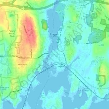
Название: Топографическая карта Mystic, высота, рельеф.
Местонахождение: Mystic, Stonington, Southeastern Connecticut Planning Region, Connecticut, 06388, United States (41.31424 -72.00640 41.39424 -71.92640)
Средняя высота: 24 м
Минимальная высота: -2 м
Максимальная высота: 95 м
Сделать пожертвование
Другие топографические карты
Нажмите на карту, чтобы просмотреть ее топографию, ее высоту и ее рельеф.
Austrailia Beach
United States > Connecticut > Southeastern Connecticut Planning Region > Mystic
Средняя высота: 19 м
Old Mystic
United States > Connecticut > Southeastern Connecticut Planning Region > Groton > Old Mystic
Средняя высота: 42 м
Сделать пожертвование
Austrailia Beach
United States > Connecticut > Southeastern Connecticut Planning Region > Mystic
Средняя высота: 19 м
Mystic
United States > Connecticut > Southeastern Connecticut Planning Region > Stonington > Mystic
Средняя высота: 15 м
Сделать пожертвование
Taftville
United States > Connecticut > Southeastern Connecticut Planning Region > Norwich
Средняя высота: 47 м
Austrailia Beach
United States > Connecticut > Southeastern Connecticut Planning Region > Mystic
Средняя высота: 19 м
Hanover Reservoir
United States > Connecticut > Southeastern Connecticut Planning Region > Hanover
Средняя высота: 91 м
Сделать пожертвование
Willimantic
United States > Connecticut > Southeastern Connecticut Planning Region > Willimantic > Windham
Средняя высота: 95 м
Mystic
United States > Connecticut > Southeastern Connecticut Planning Region > Stonington > Mystic
Средняя высота: 15 м
Taftville Reservoir #1 Dam
United States > Connecticut > Southeastern Connecticut Planning Region > Norwich
Средняя высота: 75 м
Сделать пожертвование
Blue Lake
United States > Connecticut > Southeastern Connecticut Planning Region > North Stonington
Средняя высота: 106 м
Thames River
United States > Connecticut > Southeastern Connecticut Planning Region > Waterford
Средняя высота: 52 м
Сделать пожертвование
East Lyme
United States > Connecticut > Southeastern Connecticut Planning Region
The topography of East Lyme consists of rolling hills and lush valleys rounded by glaciers during the last Ice Age. Hills rise to elevations of 250 to 350 feet (76 to 107 m) above sea level in the eastern and central areas of the town. The highest point in town is an unnamed hill with an elevation of 500 feet…
Средняя высота: 41 м
New London
United States > Connecticut > Southeastern Connecticut Planning Region
Средняя высота: 17 м
Сделать пожертвование
Сделать пожертвование
Colchester
United States > Connecticut > Southeastern Connecticut Planning Region
Средняя высота: 134 м
New London
United States > Connecticut > Southeastern Connecticut Planning Region
Средняя высота: 17 м
Сделать пожертвование
East Lyme
United States > Connecticut > Southeastern Connecticut Planning Region
The topography of East Lyme consists of rolling hills and lush valleys rounded by glaciers during the last Ice Age. Hills rise to elevations of 250 to 350 feet (76 to 107 m) above sea level in the eastern and central areas of the town. The highest point in town is an unnamed hill with an elevation of 500 feet…
Средняя высота: 41 м
Austrailia Beach
United States > Connecticut > Southeastern Connecticut Planning Region > Mystic
Средняя высота: 19 м
Stonington
United States > Connecticut > Southeastern Connecticut Planning Region
Средняя высота: 25 м
Сделать пожертвование
New London
United States > Connecticut > Southeastern Connecticut Planning Region
Средняя высота: 17 м
North Stonington
United States > Connecticut > Southeastern Connecticut Planning Region
Средняя высота: 73 м
Сделать пожертвование
Thames River
United States > Connecticut > Southeastern Connecticut Planning Region > Ledyard
Средняя высота: 52 м
Gales Ferry
United States > Connecticut > Southeastern Connecticut Planning Region > Ledyard > Gales Ferry
Средняя высота: 24 м
Сделать пожертвование
Harkness Memorial State Park
United States > Connecticut > Southeastern Connecticut Planning Region > Waterford
Средняя высота: 12 м
Stonington
United States > Connecticut > Southeastern Connecticut Planning Region
Средняя высота: 25 м
Сделать пожертвование
North Stonington
United States > Connecticut > Southeastern Connecticut Planning Region
Средняя высота: 78 м
Noank
United States > Connecticut > Southeastern Connecticut Planning Region > Groton > Noank
Средняя высота: 15 м
Stonington
United States > Connecticut > Southeastern Connecticut Planning Region
Средняя высота: 25 м
Сделать пожертвование