
Топографическая карта Port Jefferson
Интерактивная карта
Нажмите на карту, чтобы отобразить высоту.
Port Jefferson
It wasn't until 1836 that the local leadership truly initiated the community's transition from a swampish hamlet to a bustling port town. Twenty-two acres of the harborfront, which flooded with the tides, were brought to a stable elevation with the construction of a causeway. Concurrently, the village was rechristened from "Drowned Meadow" to "Port Jefferson" The name choice was in honor of Thomas Jefferson.
Об этой карте
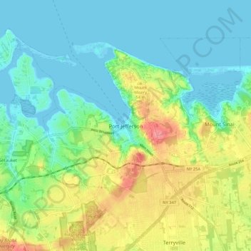
Название: Топографическая карта Port Jefferson, высота, рельеф.
Местонахождение: Port Jefferson, Suffolk County, New York, 11777, United States (40.90651 -73.10913 40.98651 -73.02913)
Средняя высота: 26 м
Минимальная высота: -4 м
Максимальная высота: 82 м