
Топографическая карта Round Rock
Интерактивная карта
Нажмите на карту, чтобы отобразить высоту.
Round Rock
The city straddles the Balcones Escarpment, a fault line in which the areas roughly east of Interstate 35 are flat and characterized by having black, fertile soils of the Blackland Prairie, and the west side of the Escarpment, which consists mostly of hilly, karst-like terrain with little topsoil and higher elevations and which is part of the Texas Hill Country. Located about 20 miles (32 km) north of downtown Austin, Round Rock shares a common border with Austin at Texas State Highway 45.
Об этой карте
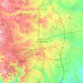
Название: Топографическая карта Round Rock, высота, рельеф.
Местонахождение: Round Rock, Williamson County, Texas, 78680, United States (30.34859 -97.83881 30.66859 -97.51881)
Средняя высота: 236 м
Минимальная высота: 147 м
Максимальная высота: 342 м