
Спасибо за поддержку этого сайта ❤️
Сделать пожертвование
Сделать пожертвование
Топографическая карта Lumding
Нажмите на карту, чтобы отобразить высоту.
Спасибо за поддержку этого сайта ❤️
Сделать пожертвование
Сделать пожертвование
Lumding
Hills of Lumding put the town a notable altitude above the sea level, but summer temperatures can reach up to 40 °C and the winters can be as chilling as 4-5 °C with fog and mist intervening in the early hours of the day. Monsoon is a notable season here, with rainfall around 60–125mm at an average. But its hills and altitude prevents any flooding in the region during heavy monsoon.
Спасибо за поддержку этого сайта ❤️
Сделать пожертвование
Сделать пожертвование
Об этой карте
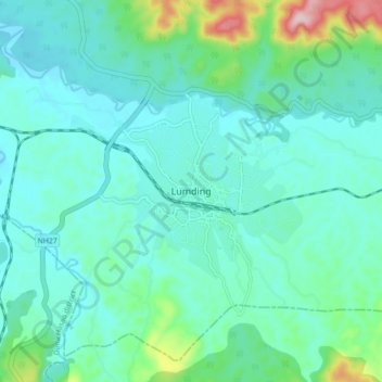
Название: Топографическая карта Lumding, высота, рельеф.
Местонахождение: Lumding, Lanka, Hojai, Assam, 782447, India (25.71354 93.13317 25.79354 93.21317)
Средняя высота: 159 м
Минимальная высота: 109 м
Максимальная высота: 388 м
Спасибо за поддержку этого сайта ❤️
Сделать пожертвование
Сделать пожертвование