
Сделать пожертвование
Топографическая карта Ely
Нажмите на карту, чтобы отобразить высоту.
Сделать пожертвование
Ely
Ely is built on a 23-square-mile (60 km2) Kimmeridge Clay island which, at 85 feet (26 m), is the highest land in the Fens. It was due to this topography that Ely was not waterlogged like the surrounding Fenland, and was an island separated from the mainland. Major rivers including the Witham, Welland, Nene and Great Ouse feed into the Fens and, until draining commenced in the eighteenth century, formed freshwater marshes and meres within which peat was laid down. Once the Fens were drained, this peat created a rich and fertile soil ideal for farming.
Сделать пожертвование
Об этой карте
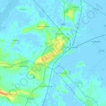
Название: Топографическая карта Ely, высота, рельеф.
Местонахождение: Ely, East Cambridgeshire, Cambridgeshire, Cambridgeshire and Peterborough, England, United Kingdom (52.36345 0.21794 52.44029 0.42529)
Средняя высота: 4 м
Минимальная высота: -5 м
Максимальная высота: 36 м
Сделать пожертвование
Другие топографические карты
Нажмите на карту, чтобы просмотреть ее топографию, ее высоту и ее рельеф.
Cambridge
United Kingdom > England > Cambridgeshire
The city, like most of the UK, has a maritime climate highly influenced by the Gulf Stream. Located in the driest region of Britain, Cambridge's rainfall averages around 570 mm (22.44 in) per year, around half the national average, The driest recent year was in 2011 with 380.4 mm (14.98 in) of rain at the…
Средняя высота: 33 м
Peterborough
United Kingdom > England > Cambridgeshire
The local topography is flat, and in some places, the land lies below sea level, for example in parts of the Fens to the east and to the south of Peterborough. Human settlement in the area began before the Bronze Age, as can be seen at the Flag Fen archaeological site to the east of the current city centre,…
Средняя высота: 17 м
River Great Ouse or Ely Ouse
United Kingdom > England > Cambridgeshire > East Cambridgeshire > Soham > Stuntney
Средняя высота: 4 м
Сделать пожертвование
Holme Fen
United Kingdom > England > Cambridgeshire > East Cambridgeshire > Haddenham
Средняя высота: 4 м
Little Ouse
United Kingdom > England > Cambridgeshire > East Cambridgeshire > Littleport
Средняя высота: -1 м
Green End
United Kingdom > England > Cambridgeshire > Huntingdonshire > Great Stukeley
Средняя высота: 32 м
Сделать пожертвование
Hinchingbrooke Country Park
United Kingdom > England > Cambridgeshire > Huntingdonshire > Huntingdon > Brampton
Средняя высота: 16 м
Сделать пожертвование
Сделать пожертвование
Сделать пожертвование
Chittering
United Kingdom > England > Cambridgeshire > South Cambridgeshire > Waterbeach
Средняя высота: 3 м
Сделать пожертвование
Eastrea
United Kingdom > England > Cambridgeshire > Fenland District > Whittlesey > Coates
Средняя высота: 3 м
Huntingdon Castle
United Kingdom > England > Cambridgeshire > Huntingdonshire > Huntingdon > Hartford
Средняя высота: 14 м
Сделать пожертвование
Odsey
United Kingdom > England > Cambridgeshire > South Cambridgeshire > Steeple Morden
Средняя высота: 82 м
Сделать пожертвование
Rack Fen
United Kingdom > England > Cambridgeshire > East Cambridgeshire > Littleport
Средняя высота: 0 м
Сделать пожертвование
Сделать пожертвование
Washingley
United Kingdom > England > Cambridgeshire > Huntingdonshire > Folksworth
Средняя высота: 48 м
Сделать пожертвование
Nine Wells
United Kingdom > England > Cambridgeshire > South Cambridgeshire > Great Shelford
Средняя высота: 20 м
Bourn Bridge
United Kingdom > England > Cambridgeshire > South Cambridgeshire > Little Abington
Средняя высота: 39 м
Сделать пожертвование
Chippenham Fen NNR (permit access)
United Kingdom > England > Cambridgeshire > East Cambridgeshire
Средняя высота: 17 м
Сделать пожертвование
Сделать пожертвование
Little Linton
United Kingdom > England > Cambridgeshire > South Cambridgeshire > Linton
Средняя высота: 62 м
Сделать пожертвование
Hartford Marina
United Kingdom > England > Cambridgeshire > Huntingdonshire > Wyton
Средняя высота: 14 м
Сделать пожертвование
Hatley's Children's Pit
United Kingdom > England > Cambridgeshire > South Cambridgeshire > Landbeach
Средняя высота: 7 м
Wisbech and Upwell Tramway
United Kingdom > England > Cambridgeshire > Fenland > Friday Bridge
Средняя высота: 3 м
Сделать пожертвование
Westwick
United Kingdom > England > Cambridgeshire > South Cambridgeshire > Oakington > Westwick
Средняя высота: 11 м
Gamlingay Wood NR
United Kingdom > England > Cambridgeshire > South Cambridgeshire > Gamlingay
Средняя высота: 56 м
Сделать пожертвование
Hayley Wood NR
United Kingdom > England > Cambridgeshire > South Cambridgeshire > Hatley
Средняя высота: 76 м
Mill Pool
United Kingdom > England > Cambridgeshire > Huntingdonshire > Huntingdon
Средняя высота: 14 м
Peterborough
United Kingdom > England > Cambridgeshire
The cathedral city of Ely is 24 miles (39 km) east-southeast across the Fens and the university city of Cambridge is 30 miles (48 km) to the southeast. The local topography is flat, and in places, the land lies below sea level.
Средняя высота: 17 м
Сделать пожертвование
Witcham Toll
United Kingdom > England > Cambridgeshire > East Cambridgeshire > Witcham
Средняя высота: 10 м
Peterborough
United Kingdom > England > Cambridgeshire
The local topography is flat, and in some places, the land lies below sea level, for example in parts of the Fens to the east and to the south of Peterborough. Human settlement in the area began before the Bronze Age, as can be seen at the Flag Fen archaeological site to the east of the current city centre,…
Средняя высота: 17 м
Сделать пожертвование
Peterborough
United Kingdom > England > Cambridgeshire
The city is 74 miles (119 km) north of London, on the River Nene which flows into The Wash 27 miles (43 km) to the north-east; the cathedral city of Ely is 24 miles (39 km) east-southeast across the Fens and the university city of Cambridge is 30 miles (48 km) to the southeast. The local topography is flat,…
Средняя высота: 17 м
Peterborough
United Kingdom > England > Cambridgeshire
The cathedral city of Ely is 24 miles (39 km) east-southeast across the Fens and the university city of Cambridge is 30 miles (48 km) to the southeast. The local topography is flat, and in places, the land lies below sea level.
Средняя высота: 17 м
Сделать пожертвование