
Топографическая карта Breany
Интерактивная карта
Нажмите на карту, чтобы отобразить высоту.
Об этой карте
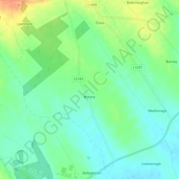
Название: Топографическая карта Breany, высота, рельеф.
Местонахождение: Breany, Ardagh East ED, Ballymahon Municipal District, County Longford, Leinster, Ireland (53.64156 -7.69416 53.66511 -7.65424)
Средняя высота: 91 м
Минимальная высота: 76 м
Максимальная высота: 118 м
Другие топографические карты
Нажмите на карту, чтобы просмотреть ее топографию, ее высоту и ее рельеф.
Lanesborough
Lanesborough, Ballymahon Municipal District, County Longford, Leinster, Ireland
Средняя высота: 41 м
Lissardowlan
Lissardowlan, Corboy ED, Longford Municipal District, County Longford, Leinster, Ireland
Средняя высота: 79 м
Annagh More
Annagh More, Mountdavis ED, Ballymahon Municipal District, County Longford, Leinster, Ireland
Средняя высота: 47 м
Laughil
Laughil, Ardagh West ED, Ballymahon Municipal District, County Longford, Leinster, Ireland
Средняя высота: 81 м
Barragh More
Barragh More, Drumlish ED, Granard Municipal District, County Longford, Leinster, Ireland
Средняя высота: 63 м
Cleggill
Cleggill, Caldragh ED, Longford Municipal District, County Longford, Leinster, Ireland
Средняя высота: 48 м
Edgeworthstown
Edgeworthstown, Edgeworthstown ED, Ballymahon Municipal District, County Longford, Leinster, N39 AH64, Ireland
Средняя высота: 94 м
Wood Town
Wood Town, Cloonmore, Killashee ED, Ballymahon Municipal District, County Longford, Leinster, Ireland
Средняя высота: 46 м
Kilshruley
Ireland > County Longford > Kilshruley
Kilshruley, Ballinalee ED, Granard Municipal District, County Longford, Leinster, Ireland
Средняя высота: 66 м
Cloonsheerin
Ireland > County Longford > Cloonsheerin
Cloonsheerin, Killashee ED, Ballymahon Municipal District, County Longford, Leinster, Ireland
Средняя высота: 50 м
Drummeel
Ireland > County Longford > Drummeel
Drummeel, Drummeel ED, Granard Municipal District, County Longford, Leinster, Ireland
Средняя высота: 72 м
Killyfad
Ireland > County Longford > Killyfad
Killyfad, Cloonee ED, Longford Municipal District, County Longford, Leinster, Ireland
Средняя высота: 59 м
Clooneen
Ireland > County Longford > Clooneen
Clooneen, Creevy ED, Granard Municipal District, County Longford, Leinster, Ireland
Средняя высота: 92 м
Elfeet Bay
Elfeet Bay, Cashel West ED, Ballymahon Municipal District, County Longford, Leinster, Ireland
Средняя высота: 40 м
Creagh
Ireland > County Longford > Creagh
Creagh, Kilcommock ED, Ballymahon Municipal District, County Longford, Leinster, Ireland
Средняя высота: 69 м
Longford
Ireland > County Longford > Longford
Longford, County Longford, Leinster, N39 V9W3, Ireland
Средняя высота: 57 м
Lough Gowna
Lough Gowna, Granard Municipal District, County Longford, Leinster, Ireland
Средняя высота: 80 м
Abbeyshrule
Ireland > County Longford > Abbeyshrule
Abbeyshrule, Agharra ED, Ballymahon Municipal District, County Longford, Leinster, Ireland
Средняя высота: 66 м