
Топографическая карта Cairo
Интерактивная карта
Нажмите на карту, чтобы отобразить высоту.
Об этой карте
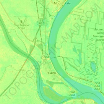
Название: Топографическая карта Cairo, высота, рельеф.
Местонахождение: Cairo, Alexander County, Illinois, 62914, United States (36.97030 -89.23146 37.08887 -89.13292)
Средняя высота: 95 м
Минимальная высота: 85 м
Максимальная высота: 107 м
Cairo (/ˈkɛəroʊ/ KAIR-oh, sometimes /ˈkeɪroʊ/ KAY-roh) is the southernmost city in Illinois and the county seat of Alexander County. A river city, Cairo has the lowest elevation of any location in Illinois and is the only Illinois city to be surrounded by levees. It is in the river-crossed area of Southern Illinois known as "Little Egypt", for which the city is named, after Egypt's capital on the Nile. The city is coterminous with Cairo Precinct.
Другие топографические карты
Нажмите на карту, чтобы просмотреть ее топографию, ее высоту и ее рельеф.
Cairo
United States > Illinois > Alexander County > Cairo > Cairo
Cairo, Alexander County, Illinois, 62914, United States
Средняя высота: 95 м
Dogtooth Bend Mounds
United States > Illinois > Alexander County
Dogtooth Bend Mounds, Alexander County, Illinois, 62962, United States
Средняя высота: 98 м
McClure
United States > Illinois > Alexander County
McClure, Alexander County, Illinois, United States
Средняя высота: 103 м
Big Cypress
United States > Illinois > Alexander County
Big Cypress, Alexander County, Illinois, 62969, United States
Средняя высота: 101 м
Thebes
United States > Illinois > Alexander County
Thebes, Alexander County, Illinois, 62990, United States
Средняя высота: 119 м