
Топографическая карта Hoshiarpur
Интерактивная карта
Нажмите на карту, чтобы отобразить высоту.
Об этой карте
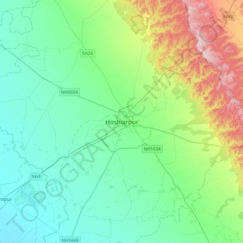
Название: Топографическая карта Hoshiarpur, высота, рельеф.
Местонахождение: Hoshiarpur, Hoshiarpur Tahsil, Hoshiarpur District, Punjab, 146001, India (31.37285 75.74255 31.69285 76.06255)
Средняя высота: 327 м
Минимальная высота: 239 м
Максимальная высота: 613 м
Hoshiarpur has an average elevation of 296 metres (971 ft). Hoshiarpur district is located in the north-east part of the Indian state of Punjab. It falls in the Jalandhar Revenue Division and is situated in the Bist Doab portion of the Doaba region. Hoshiarpur shares a boundary with Kangra district, and Una district of Himachal Pradesh in the northeast. In the southwest, it borders Shahid Bhagat Singh Nagar district, Jalandhar district, and Kapurthala district, and in the northwest it borders Gurdaspur district.