
Сделать пожертвование
Топографическая карта Bandarawela
Нажмите на карту, чтобы отобразить высоту.
Сделать пожертвование
Bandarawela
Bandarawela (Sinhala : බණ්ඩාරවෙල, pronounced [banˈda:rawela]; Tamil: பண்டாரவளை) is the second largest town in the Badulla District which is 28 km (17 mi) away from Badulla. Bandarawela is 200 km (120 mi) away from Colombo and about 125 km (78 mi) away from Kandy, the two largest cities of Sri Lanka. Thanks to its higher altitude, compared to surrounding locations, Bandarawela has milder weather conditions throughout the year making it a tourist destination for locals. Bandarawela is within hours reach of surrounding towns and cities by both road and rail. The town is influenced by its colonial history and rests among dense, lush forestation occupying a niche among visitors as a base for tourism.
Сделать пожертвование
Об этой карте
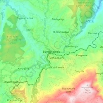
Название: Топографическая карта Bandarawela, высота, рельеф.
Местонахождение: Bandarawela, Badulla District, Uva Province, 90100, Sri Lanka (6.79048 80.94882 6.87048 81.02882)
Средняя высота: 1 293 м
Минимальная высота: 948 м
Максимальная высота: 1 943 м
Сделать пожертвование
Другие топографические карты
Нажмите на карту, чтобы просмотреть ее топографию, ее высоту и ее рельеф.
Yala National Park
The Yala area is mostly composed of metamorphic rock belonging to the Precambrian era and classified into two series, Vijayan series and Highland series. Reddish brown soil and low humic grey soil are prominent among six soil types. Yala is situated in the lowest peneplain of Sri Lanka, which extends from…
Средняя высота: 65 м