
Сделать пожертвование
Топографическая карта Bend
Нажмите на карту, чтобы отобразить высоту.
Сделать пожертвование
Bend
Bend is characterized by its distinctive topography, situated at an elevation of approximately 3,623 feet (1,105 meters) above sea level. The city lies within the high desert region of Central Oregon, bordered by the Cascade Mountains to the west, which provide a dramatic backdrop with peaks like the Three Sisters and Mount Bachelor. The terrain features a mix of rolling hills, plateaus, and valleys, interspersed with the winding Deschutes River that flows through the city, creating scenic landscapes and recreational opportunities. This region's varied elevation contributes to a diverse ecosystem, from arid high desert scrub to lush riverbanks, making Bend a prime location for outdoor activities such as hiking, biking, and skiing.
Сделать пожертвование
Об этой карте
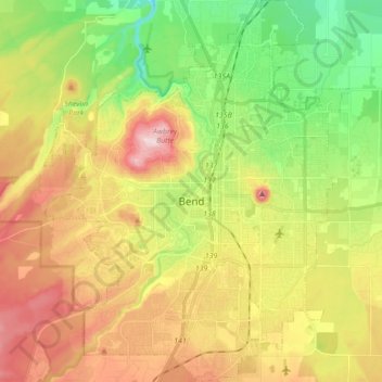
Название: Топографическая карта Bend, высота, рельеф.
Местонахождение: Bend, Deschutes County, Oregon, United States (43.99906 -121.38243 44.12375 -121.24335)
Средняя высота: 1 121 м
Минимальная высота: 985 м
Максимальная высота: 1 286 м
Сделать пожертвование
Другие топографические карты
Нажмите на карту, чтобы просмотреть ее топографию, ее высоту и ее рельеф.
Mount Bachelor
United States > Oregon > Deschutes County
Mount Bachelor lies in the Cascade Range, within Deschutes County, in the U.S. state of Oregon. It is located south of the Three Sisters complex volcano, and reaches an elevation of 9,068 feet (2,764 m). It rises 3,500 feet (1,100 m) above its base, with a proximal relief of 2,674 feet (815 m). The volcano has…
Средняя высота: 2 325 м
South Sister
United States > Oregon > Deschutes County
The Three Sisters are closely spaced volcanic peaks in the U.S. state of Oregon. They are part of the Cascade Volcanic Arc, a segment of the Cascade Range in western North America extending from southern British Columbia through Washington and Oregon to Northern California. Each over 10,000 feet (3,000 meters)…
Средняя высота: 2 634 м
Сделать пожертвование
Pilot Butte
United States > Oregon > Deschutes County > Bend
The 114.22-acre (46.22-hectare) Pilot Butte State Scenic Viewpoint, presented as a gift to the State of Oregon in 1928, is a Bend icon. Pilot Butte itself is a popular hiking destination with two trails to the summit, each gaining about 490 ft (150 m) in elevation. There is also a 1.8-mile (2.9 km) trail…
Средняя высота: 1 112 м
Сделать пожертвование
Three Sisters
United States > Oregon > Deschutes County
The Three Sisters are closely spaced volcanic peaks in the U.S. state of Oregon. They are part of the Cascade Volcanic Arc, a segment of the Cascade Range in western North America extending from southern British Columbia through Washington and Oregon to Northern California. Each over 10,000 feet (3,000 meters)…
Средняя высота: 2 526 м