
Топографическая карта Conservation Area
Нажмите на карту, чтобы отобразить высоту.
Об этой карте
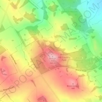
Название: Топографическая карта Conservation Area, высота, рельеф.
Средняя высота: 168 м
Минимальная высота: 75 м
Максимальная высота: 247 м
Другие топографические карты
Нажмите на карту, чтобы просмотреть ее топографию, ее высоту и ее рельеф.
South Croxton
United Kingdom > England > Leicestershire > Charnwood > South Croxton
The highest point is the church, at 120 m above mean sea level. The lowest altitude is 85 m by the Queniborough Brook.
Средняя высота: 108 м
Queniborough
United Kingdom > England > Leicestershire > Charnwood > Queniborough
Средняя высота: 75 м
Beeby
United Kingdom > England > Leicestershire > Charnwood
The physical and historical development of the hamlet has been strongly influenced by the local topography and its relative isolation. Beeby is situated within an established agricultural landscape largely in pastoral use. Until 1904 the east-west route was the only route through the hamlet, which was referred…
Средняя высота: 101 м
Barrow upon Soar
United Kingdom > England > Leicestershire > Charnwood > Barrow upon Soar
Средняя высота: 62 м
Charnwood Water
United Kingdom > England > Leicestershire > Charnwood > Woodthorpe
Средняя высота: 47 м
Old John
United Kingdom > England > Leicestershire > Charnwood > Newtown Linford
Средняя высота: 143 м
Six Hills
United Kingdom > England > Leicestershire > Charnwood > Burton on the Wolds
Средняя высота: 128 м
East Goscote
United Kingdom > England > Leicestershire > Charnwood > East Goscote
Средняя высота: 61 м
Barrow upon Soar
United Kingdom > England > Leicestershire > Charnwood > Barrow upon Soar
Средняя высота: 62 м