
Сделать пожертвование
Топографическая карта Florence
Нажмите на карту, чтобы отобразить высоту.
Сделать пожертвование
Florence
Florence is located in the coastal plain of South Carolina. It is in the northeastern part of the state and the northern part of Florence County. The average elevation above sea level is around 140 ft (43 m). Jeffries Creek is a tributary of the Great Pee Dee River and is the main waterway that flows through the city, passing south of the city center. According to the United States Census Bureau, the city has a total area of 23.49 square miles (60.8 km2), of which 23.39 square miles (60.6 km2) is land and 0.09 square miles (0.23 km2) (0.38%) is water.
Сделать пожертвование
Об этой карте
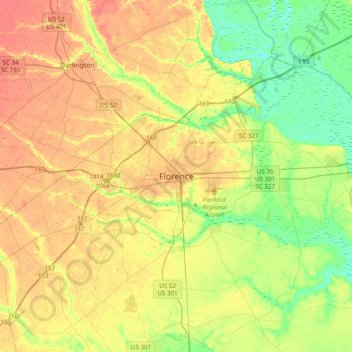
Название: Топографическая карта Florence, высота, рельеф.
Местонахождение: Florence, Florence County, South Carolina, 29502, United States (34.03844 -79.92717 34.35844 -79.60717)
Средняя высота: 35 м
Минимальная высота: 9 м
Максимальная высота: 62 м
Сделать пожертвование
Другие топографические карты
Нажмите на карту, чтобы просмотреть ее топографию, ее высоту и ее рельеф.
Florence
United States > South Carolina > Florence County
Florence is located in the coastal plain of South Carolina. It is in the northeastern part of the state and the northern part of Florence County. The average elevation above sea level is around 140 ft (43 m). Jeffries Creek is a tributary of the Great Pee Dee River and is the main waterway that flows through…
Средняя высота: 37 м
Florence Soccer Complex
United States > South Carolina > Florence County > Florence
Средняя высота: 42 м
Сделать пожертвование
Florence
United States > South Carolina > Florence County
Florence is located in the coastal plain of South Carolina. It is in the northeastern part of the state and the northern part of Florence County. The average elevation above sea level is around 140 ft (43 m). Jeffries Creek is a tributary of the Great Pee Dee River and is the main waterway that flows through…
Средняя высота: 37 м