
Сделать пожертвование
Топографическая карта Bodensdorf
Нажмите на карту, чтобы отобразить высоту.
Сделать пожертвование
Об этой карте
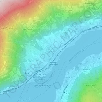
Название: Топографическая карта Bodensdorf, высота, рельеф.
Местонахождение: Bodensdorf, Steindorf am Ossiacher See, Bezirk Feldkirchen, Carinthia, 9552, Austria (46.66609 13.95257 46.70609 13.99257)
Средняя высота: 716 м
Минимальная высота: 498 м
Максимальная высота: 1 515 м
Сделать пожертвование
Другие топографические карты
Нажмите на карту, чтобы просмотреть ее топографию, ее высоту и ее рельеф.
Pasterze
Austria > Carinthia > Bezirk Spittal an der Drau > Heiligenblut am Großglockner
Средняя высота: 2 599 м
Сделать пожертвование
Millstatt am See
Austria > Carinthia > Bezirk Spittal an der Drau
It is situated on the southern slope of the Gurktal Alps (Nock Mountains), on an alluvial fan peninsula on the lake's northern shore. The municipal area reaches from an elevation of 588 m (1,929 ft) at the lakeside to 2,101 m (6,893 ft) AA at the crest of the Millstätter Alpe massif. It comprises the…
Средняя высота: 1 149 м
Сделать пожертвование
Lake Wörth
Austria > Carinthia > Bezirk Klagenfurt-Land > Schiefling am Wörthersee
Средняя высота: 619 м
Сделать пожертвование
Сделать пожертвование
Dellach
Austria > Carinthia > Bezirk Hermagor
The municipal area lies in the upper Gail valley, between the neighbouring municipalities of Kötschach-Mauthen in the west and Kirchbach in the east. The Carnic Alps in the south form the border with Paularo in Italy. In the north rises Mt. Reißkofel, the highest peak of the Gailtal Alps east of the Lienz…
Средняя высота: 1 233 м
Сделать пожертвование
Lake Faak
Austria > Carinthia > Bezirk Villach-Land > Finkenstein am Faaker See > Faak am See
Средняя высота: 572 м
Сделать пожертвование
Lake Pressegg
Austria > Carinthia > Bezirk Hermagor > Hermagor-Pressegger See > Presseggersee > Paßriach
Средняя высота: 627 м
Bad Kleinkirchheim
Austria > Carinthia > Bezirk Spittal an der Drau
Bad Kleinkirchheim is at an average elevation of 1,087 m (3,566 ft) in a 5 km (3 mi) stretch of a glacial trough valley in the Gurktal Alps (Nock Mountains), between the Millstätter See and the upper Gurk River. The populated section lies between 980 m (3,215 ft) and 1,380 m (4,528 ft), and the highest point…
Средняя высота: 1 605 м
Сделать пожертвование
Сделать пожертвование
Сделать пожертвование
Bad Kleinkirchheim
Austria > Carinthia > Bezirk Spittal an der Drau
Bad Kleinkirchheim is at an average elevation of 1,087 m (3,566 ft) in a 5 km (3 mi) stretch of a glacial trough valley in the Gurktal Alps (Nock Mountains), between the Millstätter See and the upper Gurk River. The populated section lies between 980 m (3,215 ft) and 1,380 m (4,528 ft), and the highest point…
Средняя высота: 1 605 м
Lavamünd
Austria > Carinthia > Bezirk Wolfsberg
Lavamünd lies in the southeast of Carinthia, close to the border with Slovenia (Slovene Carinthia). It is situated at the confluence of the Lavant and Drava rivers. In the northeast, the Soboth Pass leads across the Koralpe range to Eibiswald in Styria. At an elevation of 348 m (1,142 ft) AA, the area is the…
Средняя высота: 768 м
Сделать пожертвование
Сделать пожертвование
High Tauern National Park
Austria > Carinthia > Bezirk Spittal an der Drau > Heiligenblut am Großglockner
Средняя высота: 1 710 м
Сделать пожертвование
Friesach
Austria > Carinthia > Bezirk Sankt Veit an der Glan
Friesach covers an area of 120.83 km2 and its mean elevation is 631 meters above sea level. It is located in northern Carinthia near the border with Styria, about 40 km (25 mi) north of its capital Klagenfurt.
Средняя высота: 1 044 м
Сделать пожертвование
Сделать пожертвование