
Сделать пожертвование
Топографическая карта Mount Kinabalu
Нажмите на карту, чтобы отобразить высоту.
Сделать пожертвование
Mount Kinabalu
Mount Kinabalu (Malay: Gunung Kinabalu, Dusun: Gayo Ngaran or Nulu Nabalu) is the highest mountain in Borneo and Malaysia. With an elevation of 13,435 feet (4,095 m), it is third-highest peak of an island on Earth, and 20th most prominent mountain in the world by topographic prominence. The mountain is located in Ranau district, West Coast Division of Sabah, Malaysia. It is protected as Kinabalu Park, a World Heritage Site.
Сделать пожертвование
Об этой карте
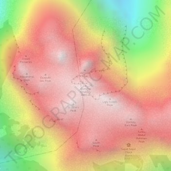
Название: Топографическая карта Mount Kinabalu, высота, рельеф.
Местонахождение: Mount Kinabalu, Ranau, West Coast Division, Sabah, Malaysia (6.07502 116.55865 6.07512 116.55875)
Средняя высота: 3 567 м
Минимальная высота: 2 661 м
Максимальная высота: 4 062 м
Сделать пожертвование
Другие топографические карты
Нажмите на карту, чтобы просмотреть ее топографию, ее высоту и ее рельеф.
Сделать пожертвование
Kinabalu Park
Malaysia > Sabah > Ranau > Tinompok
The park headquarters is 88 kilometres away from the city of Kota Kinabalu. There are sealed roads leading towards the park headquarters from other parts of Sabah. It is situated on the southern boundary of Kinabalu Park, at an elevation of 1,563 m (5,128 ft).
Средняя высота: 2 063 м