
Сделать пожертвование
Топографическая карта Axalp
Нажмите на карту, чтобы отобразить высоту.
Сделать пожертвование
Об этой карте
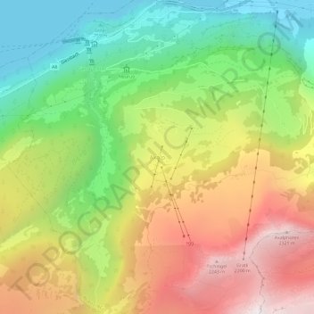
Название: Топографическая карта Axalp, высота, рельеф.
Средняя высота: 1 369 м
Минимальная высота: 557 м
Максимальная высота: 2 359 м
Сделать пожертвование
Другие топографические карты
Нажмите на карту, чтобы просмотреть ее топографию, ее высоту и ее рельеф.
Lauterbrunnen
Switzerland > Bern > Interlaken-Oberhasli administrative district
Средняя высота: 2 316 м
Сделать пожертвование
Iseltwald
Switzerland > Bern > Interlaken-Oberhasli administrative district
The municipality's area also includes a large area of mountainside along the south shore of the lake, of which the lower areas are heavily wooded. These slopes extend up to the summit of the Faulhorn mountain, at an altitude of 2,680 m (8,790 ft).
Средняя высота: 1 218 м
Lauterbrunnen
Switzerland > Bern > Interlaken-Oberhasli administrative district
Средняя высота: 2 316 м
Сделать пожертвование
Meiringen
Switzerland > Bern > Interlaken-Oberhasli administrative district
On the right bank of the Aare, the municipality of Meiringen rises from an elevation of 600 m (2,000 ft) on the valley floor to the Brünig Pass at 1,008 m (3,307 ft) and beyond that to a point at 1,375 m (4,511 ft) on the slopes of the Wilerhorn. On the left bank it stretches up into the Alps and reaches an…
Средняя высота: 1 430 м
Gündlischwand
Switzerland > Bern > Interlaken-Oberhasli administrative district
Средняя высота: 1 268 м
Сделать пожертвование
Innertkirchen
Switzerland > Bern > Interlaken-Oberhasli administrative district > Innertkirchen
The large alpine municipality is located at the confluence of the Urbach and Gadmer streams into the Aare river. It includes the Urbach valley, the Gadmen valley, the Gen valley, the Wetterhorn mountain and the Gauli Glacier. Innertkirchen was created out of the Bäuerten (farming communities) of Grund,…
Средняя высота: 1 945 м
Сделать пожертвование
Сделать пожертвование
Wilderswil
Switzerland > Bern > Interlaken-Oberhasli administrative district
The municipality extends for some 8 km (5.0 mi) from the village, along the west bank of the Lütschine river, and includes the flanks of the mountains that border that valley to the west. Its altitude ranges from some 580 m (1,900 ft), on the Bödeli plain, to 2,413 m (7,917 ft), at the summit of Sulegg. It…
Средняя высота: 1 198 м
Сделать пожертвование
Matten bei Interlaken
Switzerland > Bern > Interlaken-Oberhasli administrative district
Средняя высота: 781 м
Innertkirchen
Switzerland > Bern > Interlaken-Oberhasli administrative district
The large alpine municipality is located at the confluence of the Urbach and Gadmer streams into the Aare river. It includes the Urbach valley, the Gadmen valley, the Gen valley, the Wetterhorn mountain and the Gauli Glacier. Innertkirchen was created out of the Bäuerten (farming communities) of Grund,…
Средняя высота: 1 963 м
Triftsee
Switzerland > Bern > Interlaken-Oberhasli administrative district > Innertkirchen
Средняя высота: 2 025 м
Lauterbrunnen
Switzerland > Bern > Interlaken-Oberhasli administrative district
Средняя высота: 2 316 м
Сделать пожертвование
Meiringen
Switzerland > Bern > Interlaken-Oberhasli administrative district
On the right bank of the Aare, the municipality of Meiringen rises from an elevation of 600 m (2,000 ft) on the valley floor to the Brünig Pass at 1,008 m (3,307 ft) and beyond that to a point at 1,375 m (4,511 ft) on the slopes of the Wilerhorn. On the left bank it stretches up into the Alps and reaches an…
Средняя высота: 1 430 м
Matten bei Interlaken
Switzerland > Bern > Interlaken-Oberhasli administrative district
Средняя высота: 781 м
Lauterbrunnen
Switzerland > Bern > Interlaken-Oberhasli administrative district
Средняя высота: 2 316 м
Сделать пожертвование
Guttannen
Switzerland > Bern > Interlaken-Oberhasli administrative district
By Swiss standards, the municipality is large in area; by comparison it is larger than the entire Canton of Appenzell Innerrhoden. In elevation it stretches from the valley floor which is between 800–1,300 m (2,600–4,300 ft) into the high alpine peaks of the Finsteraarhorn group.
Средняя высота: 2 334 м
Lauterbrunnen
Switzerland > Bern > Interlaken-Oberhasli administrative district
Средняя высота: 2 316 м
Gsteigwiler
Switzerland > Bern > Interlaken-Oberhasli administrative district > Gsteigwiler
Средняя высота: 984 м
Сделать пожертвование
Unteraargletscher
Switzerland > Bern > Interlaken-Oberhasli administrative district > Guttannen
Средняя высота: 2 631 м