
Сделать пожертвование
Топографическая карта Robertsbridge
Нажмите на карту, чтобы отобразить высоту.
Сделать пожертвование
Об этой карте
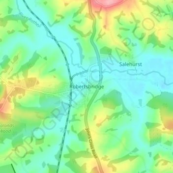
Название: Топографическая карта Robertsbridge, высота, рельеф.
Местонахождение: Robertsbridge, Rother, East Sussex, England, TN32 5AL, United Kingdom (50.96564 0.45445 51.00564 0.49445)
Средняя высота: 38 м
Минимальная высота: 4 м
Максимальная высота: 118 м
Сделать пожертвование
Другие топографические карты
Нажмите на карту, чтобы просмотреть ее топографию, ее высоту и ее рельеф.
Сделать пожертвование
Rye
United Kingdom > England > East Sussex > Rother > Playden
The town and its striking surroundings have frequently served as subject for painters, many of whose works are now on display in its art gallery. One of the earliest topographical panoramas, dating from the 17th century when the town was still an island port, is in the style of Hendrick Danckerts and on…
Средняя высота: 7 м
Сделать пожертвование
Сделать пожертвование
Сделать пожертвование
Сделать пожертвование
Сделать пожертвование
Сделать пожертвование
Сделать пожертвование
Rye
United Kingdom > England > East Sussex > Rother > Playden
The town and its striking surroundings have frequently served as subject for painters, many of whose works are now on display in its art gallery. One of the earliest topographical panoramas, dating from the 17th century when the town was still an island port, is in the style of Hendrick Danckerts and on…
Средняя высота: 7 м
Сделать пожертвование
Rye
United Kingdom > England > East Sussex > Rother
The town and its striking surroundings have frequently served as subject for painters, many of whose works are now on display in its art gallery. One of the earliest topographical panoramas, dating from the 17th century when the town was still an island port, is in the style of Hendrick Danckerts and on…
Средняя высота: 7 м
Сделать пожертвование