
Сделать пожертвование
Топографическая карта Silver City
Нажмите на карту, чтобы отобразить высоту.
Сделать пожертвование
Silver City
During the period from 1901 to 1964, when readings were taken at the city center (which is cooler and wetter than outlying and lower-elevation districts nearby), the coldest temperature recorded was −13 °F (−25 °C) on January 11, 1962, and the hottest 105 °F (40.6 °C) on July 5, 1901. The coldest month was January 1949, with a monthly mean temperature of 28.7 °F or −1.8 °C, and the hottest, July 1951, which averaged 77.4 °F or 25.2 °C. The wettest calendar year in this time span was 1914, with 24.97 inches or 634.2 millimetres and the driest, 1947 with 6.77 inches or 172.0 millimetres. The most snow in one season was 48.0 inches or 1.22 metres between July 1912 and June 1913, which featured the coldest winter on record with 33.1 °F or 0.6 °C as the mean from December to February.
Сделать пожертвование
Об этой карте
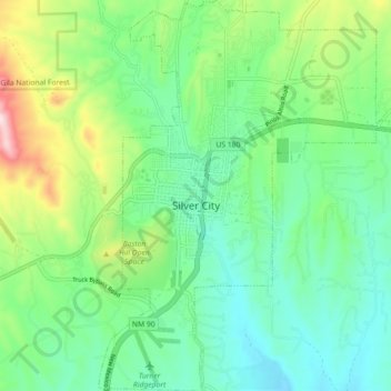
Название: Топографическая карта Silver City, высота, рельеф.
Местонахождение: Silver City, Grant County, New Mexico, United States (32.73527 -108.29886 32.81071 -108.22398)
Средняя высота: 1 851 м
Минимальная высота: 1 733 м
Максимальная высота: 2 151 м
Сделать пожертвование
Другие топографические карты
Нажмите на карту, чтобы просмотреть ее топографию, ее высоту и ее рельеф.
City of Rocks State Park
United States > New Mexico > Grant County
The City of Rocks State Park is also home to two main hiking trails: the Hydra trail, the Table Mountain trail, and the newly added Cienega Trail. The Hydra trail is 3.3 miles long with an elevation gain of 164ft. The Table Mountain trail is 3 miles long with an elevation gain of 695 ft. And the Cienega is…
Средняя высота: 1 596 м