
Сделать пожертвование
Топографическая карта Cannon Beach
Нажмите на карту, чтобы отобразить высоту.
Сделать пожертвование
Cannon Beach
Cannon Beach is recognized by the well-known landmark Haystack Rock, located southwest of downtown Cannon Beach. This sea stack has an elevation of 235 feet (72 m) and is often accessible at low tide, especially in the summertime. There is a small cave system that penetrates its igneous rock that can be seen from the coastline. The rock is also protected as part of Oregon Islands National Wildlife Refuge and events are not allowed within 100 feet (30 m) of either side of the rock. Near Haystack Rock are the Needles, two tall rocks rising straight out of the water.
Сделать пожертвование
Об этой карте
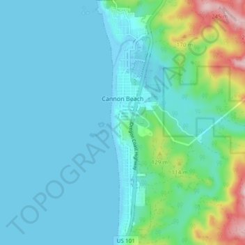
Название: Топографическая карта Cannon Beach, высота, рельеф.
Местонахождение: Cannon Beach, Clatsop County, Oregon, United States (45.85893 -123.97004 45.91103 -123.94945)
Средняя высота: 42 м
Минимальная высота: -3 м
Максимальная высота: 250 м
Сделать пожертвование
Другие топографические карты
Нажмите на карту, чтобы просмотреть ее топографию, ее высоту и ее рельеф.
Сделать пожертвование
Saddle Mountain
United States > Oregon > Clatsop County
The hike to the taller of the two peaks is a 6-mile (9.7 km) round trip consisting of challenging terrain. Elevation gain is 1,603 feet (489 m) and leads to a 360-degree view to the Pacific Ocean, Cascade Mountain peaks such as Mount Hood, Mount St. Helens, Mount Rainier, Mount Adams, and other peaks in the…
Средняя высота: 527 м
Сделать пожертвование