
Спасибо за поддержку этого сайта ❤️
Сделать пожертвование
Сделать пожертвование
Топографическая карта Sheridan
Нажмите на карту, чтобы отобразить высоту.
Спасибо за поддержку этого сайта ❤️
Сделать пожертвование
Сделать пожертвование
Sheridan
The South Yamhill River divides the city between north and south, and is prone to flooding the city. Deer Creek is the only other stream in the city. Sheridan is located in the western part of the Willamette Valley at an elevation of 189 feet (58 m) above sea level. The city lies at the foothills of the Northern Oregon Coast Range.
Спасибо за поддержку этого сайта ❤️
Сделать пожертвование
Сделать пожертвование
Об этой карте
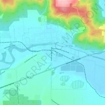
Название: Топографическая карта Sheridan, высота, рельеф.
Местонахождение: Sheridan, Yamhill County, Oregon, United States (45.08207 -123.43244 45.10937 -123.37708)
Средняя высота: 85 м
Минимальная высота: 52 м
Максимальная высота: 217 м
Спасибо за поддержку этого сайта ❤️
Сделать пожертвование
Сделать пожертвование
Другие топографические карты
Нажмите на карту, чтобы просмотреть ее топографию, ее высоту и ее рельеф.