
Топографическая карта Ball Ground
Интерактивная карта
Нажмите на карту, чтобы отобразить высоту.
Об этой карте
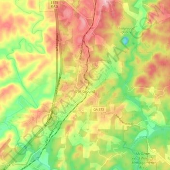
Название: Топографическая карта Ball Ground, высота, рельеф.
Местонахождение: Ball Ground, Cherokee County, Georgia, United States (34.31118 -84.41254 34.37075 -84.32178)
Средняя высота: 331 м
Минимальная высота: 243 м
Максимальная высота: 414 м
According to the United States Census Bureau as of 2020, Ball Ground has a total area of 6.3 sq mi (16 km2), of which 0.04 sq mi (0.10 km2), or 0.63%, is water. The city's elevation averages around 1,100 ft (340 m) above sea level, ranging from just over 1,000 ft (300 m) in the valleys to around 1,200 ft (370 m) on several hilltops within the city. Unlike most other parts of Cherokee County, Ball Ground is not in a floodplain and has no typically flood prone areas. To protect the water and surrounding lands, the city government has ordinances in place for stream buffer protection, watershed protection, and wetland protection.
Другие топографические карты
Нажмите на карту, чтобы просмотреть ее топографию, ее высоту и ее рельеф.
North Canton
United States > Georgia > Cherokee County > Canton
North Canton, Canton, Cherokee County, Georgia, 30114, United States
Средняя высота: 292 м
Waleska
United States > Georgia > Cherokee County
Waleska, Cherokee County, Georgia, United States
Средняя высота: 335 м
Salacoa
United States > Georgia > Cherokee County
Salacoa, Cherokee County, Georgia, United States
Средняя высота: 326 м
Garland Mountain
United States > Georgia > Cherokee County
Garland Mountain, Cherokee County, Georgia, 30183, United States
Средняя высота: 379 м
Canton
United States > Georgia > Cherokee County
Canton, Cherokee County, Georgia, 30114, United States
Средняя высота: 320 м
Waleska
United States > Georgia > Cherokee County > Waleska
Waleska, Cherokee County, Georgia, 30183, United States
Средняя высота: 338 м
Woodstock
United States > Georgia > Cherokee County
Woodstock, Cherokee County, Georgia, United States
Средняя высота: 296 м