
Сделать пожертвование
Топографическая карта Clarksville
Нажмите на карту, чтобы отобразить высоту.
Сделать пожертвование
Об этой карте
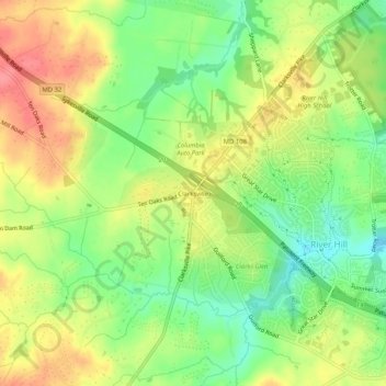
Название: Топографическая карта Clarksville, высота, рельеф.
Местонахождение: Clarksville, Columbia, Howard County, Maryland, 21029, United States (39.18654 -76.96292 39.22654 -76.92292)
Средняя высота: 134 м
Минимальная высота: 96 м
Максимальная высота: 173 м
Сделать пожертвование
Другие топографические карты
Нажмите на карту, чтобы просмотреть ее топографию, ее высоту и ее рельеф.
Columbia
United States > Maryland > Howard County > Columbia
The primary landforms in Columbia are rolling hills and stream valleys; Columbia's road network is laid out to follow the terrain, with many winding streets and cul-de-sacs. Elevations range from about 200 to 500 feet (61 to 152 m) above sea level. Most of Columbia is drained by the Middle Patuxent and Little…
Средняя высота: 113 м
Columbia
United States > Maryland > Howard County > Columbia
The primary landforms in Columbia are rolling hills and stream valleys; Columbia's road network is laid out to follow the terrain, with many winding streets and cul-de-sacs. Elevations range from about 200 to 500 feet (61 to 152 m) above sea level. Most of Columbia is drained by the Middle Patuxent and Little…
Средняя высота: 114 м
Howard County Conservancy at Mt. Pleasant
United States > Maryland > Howard County > Columbia
Средняя высота: 135 м
Сделать пожертвование