
Топографическая карта Grass Valley
Интерактивная карта
Нажмите на карту, чтобы отобразить высоту.
Grass Valley
The city of Grass Valley is the largest city in the western region of Nevada County, California, United States. Situated at roughly 2,500 feet (760 m) elevation in the western foothills of the Sierra Nevada mountain range, this historic northern Gold Country city is 57 miles (92 km) by car from the state capitol in Sacramento, 64 miles (103 km) from Sacramento International Airport, 88 miles (142 km) west of Reno, and 143 miles (230 km) northeast of San Francisco. As of the 2010 United States Census, its population was 12,860.
Об этой карте
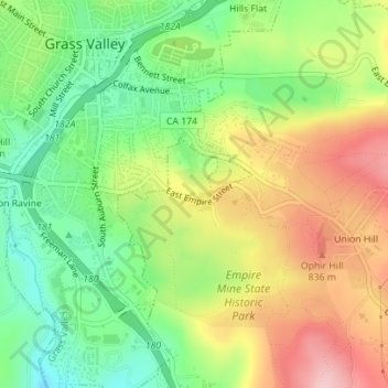
Название: Топографическая карта Grass Valley, высота, рельеф.
Местонахождение: Grass Valley, Nevada County, California, United States of America (39.20808 -121.05380 39.20908 -121.05264)
Средняя высота: 777 м
Минимальная высота: 691 м
Максимальная высота: 882 м