
Сделать пожертвование
Топографическая карта Caldas Novas
Нажмите на карту, чтобы отобразить высоту.
Сделать пожертвование
Caldas Novas
The most important study about the thermal ism of Caldas Novas and the Rio Quente was carried out by the state enterprise Furnas Centrais Elétricas, due to the possible influence of the Usina Hidrelétrica Corumbá I dam on the thermal water table of the region, which would be under the risk of cooling. According to Furnas, the phenomenon of the hot water is produced by peculiar geological and topographic characteristics. For years it was thought that a volcano had existed in the area in whose crater rainwater infiltrated, heating at great depths and then returning to the surface by way of cracks in the rock. More modern studies show that there is no indication of volcanic activity in the region. Studies show that the water is formed by rainfall that is stored in a layer of quartzite and due to pressure is sent to the surface in a column 600 meters.
Сделать пожертвование
Об этой карте
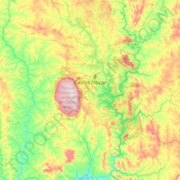
Название: Топографическая карта Caldas Novas, высота, рельеф.
Средняя высота: 694 м
Минимальная высота: 510 м
Максимальная высота: 1 046 м
Сделать пожертвование
Другие топографические карты
Нажмите на карту, чтобы просмотреть ее топографию, ее высоту и ее рельеф.
Сделать пожертвование
Rosa
Brazil > Goiás > Região Integrada de Desenvolvimento do Distrito Federal e Entorno > Pirenópolis
Средняя высота: 780 м
Bom Jesus
Brazil > Goiás > Região Integrada de Desenvolvimento do Distrito Federal e Entorno > Pirenópolis
Средняя высота: 760 м
Сделать пожертвование
Rio Arraial Velho
Brazil > Goiás > Região Integrada de Desenvolvimento do Distrito Federal e Entorno > Água Fria de Goiás
Средняя высота: 847 м
Paiol Velho
Brazil > Goiás > Região Integrada de Desenvolvimento do Distrito Federal e Entorno > Pirenópolis
Средняя высота: 730 м