
Сделать пожертвование
Топографическая карта Lewisville
Нажмите на карту, чтобы отобразить высоту.
Сделать пожертвование
Lewisville
Lewisville is at 33°2′18″N 97°0′22″W / 33.03833°N 97.00611°W / 33.03833; -97.00611 (33.038316, −97.006232) at an elevation of about 550 feet (170 m). It has a total area of 42.47 square miles (110.0 km2), of which 36.4 sq mi (94 km2) is land. It lies at the southern end of Denton County and the northern end of the Dallas–Fort Worth metroplex, in the eastern part of the Cross Timbers region of Texas between the Texas Blackland Prairies and the Grand Prairie. Vista Ridge, a small plateau, is in the southeast corner of Lewisville, and the lowest part of Denton County, at 484 feet (148 m), is found in the city. Lewisville sits above the Barnett Shale, a geological formation containing a large quantity of natural shale gas.
Сделать пожертвование
Об этой карте
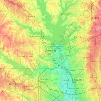
Название: Топографическая карта Lewisville, высота, рельеф.
Местонахождение: Lewisville, Denton County, Texas, 75067, United States (32.88623 -97.15417 33.20623 -96.83417)
Средняя высота: 174 м
Минимальная высота: 125 м
Максимальная высота: 242 м
Сделать пожертвование