
Сделать пожертвование
Топографическая карта Bengaluru
Нажмите на карту, чтобы отобразить высоту.
Сделать пожертвование
Bengaluru
Bengaluru (formerly Bangalore) is situated in the southeastern part of Karnataka, India, within the Bengaluru Urban district. It lies at an elevation of approximately 900 meters (3,000 feet) above sea level, on the Deccan Plateau. This elevated position gives the city a moderate climate, with temperatures rarely reaching extremes. The terrain around Bengaluru is characterized by rolling hills, rocky outcrops, and lush greenery, particularly on the outskirts. While the city itself is relatively flat, the surrounding landscape includes small hills and valleys, especially in areas like the Nandi Hills to the north, which is a prominent feature of the region’s topography. The city's varied elevation adds to its scenic beauty, offering expansive views of the countryside, lakes, and parks that dot the landscape. The mix of urban development and natural topography makes Bengaluru's setting unique in terms of both natural and man-made features.
Сделать пожертвование
Об этой карте
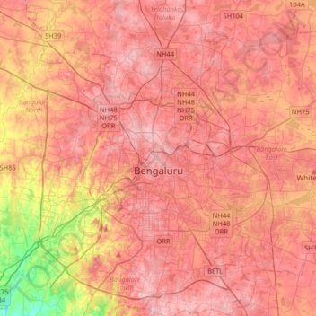
Название: Топографическая карта Bengaluru, высота, рельеф.
Местонахождение: Bengaluru, Bangalore North, Bengaluru Urban, Karnataka, India (12.83363 77.46005 13.14266 77.78436)
Средняя высота: 886 м
Минимальная высота: 731 м
Максимальная высота: 965 м
Сделать пожертвование
Другие топографические карты
Нажмите на карту, чтобы просмотреть ее топографию, ее высоту и ее рельеф.
Сделать пожертвование
Сделать пожертвование
Bengaluru
India > Karnataka > Bangalore North
Bengaluru lies in the southeast of the South Indian state of Karnataka in the heart of the Mysore Plateau (a region of the larger Deccan Plateau) at an average elevation of 900 m (2,953 ft). The city covers an area of 741 km2 (286 sq mi). The Bengaluru metropolitan region covers an area of 7,005 km2 (2,705 sq…
Средняя высота: 879 м
Сделать пожертвование
Сделать пожертвование