
Топографическая карта Ossipee
Интерактивная карта
Нажмите на карту, чтобы отобразить высоту.
Об этой карте
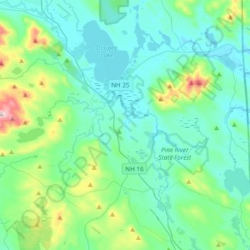
Название: Топографическая карта Ossipee, высота, рельеф.
Местонахождение: Ossipee, Carroll County, New Hampshire, United States (43.63642 -71.27994 43.83284 -71.01360)
Средняя высота: 217 м
Минимальная высота: 114 м
Максимальная высота: 715 м
The two primary settlements in town are Center Ossipee, located near the southern junction of routes 16 and 25, and Ossipee Corner (shown as "Ossipee" on topographic maps), located 5 miles (8 km) south of Center Ossipee at the junction of routes 28 and 171 and close to Route 16. Other villages include West Ossipee, at the northern junction of routes 16 and 25 near the border with Tamworth; Moultonville, directly west of Center Ossipee; and Water Village, along Route 171 near the border with Tuftonboro.
Другие топографические карты
Нажмите на карту, чтобы просмотреть ее топографию, ее высоту и ее рельеф.
Eaton
United States > New Hampshire > Carroll County
Eaton, Carroll County, New Hampshire, 03832, United States
Средняя высота: 262 м
Sandwich
United States > New Hampshire > Carroll County
Sandwich, Carroll County, New Hampshire, 03259, United States
Средняя высота: 373 м
Flat Mountain
United States > New Hampshire > Carroll County > Sandwich
Flat Mountain, Sandwich, Carroll County, New Hampshire, United States
Средняя высота: 629 м
Moultonborough
United States > New Hampshire > Carroll County
Moultonborough, Carroll County, New Hampshire, United States
Средняя высота: 243 м
Albany
United States > New Hampshire > Carroll County > Albany
Albany, Carroll County, New Hampshire, United States
Средняя высота: 276 м
Bayle Mountain
United States > New Hampshire > Carroll County > Ossipee
Bayle Mountain, Ossipee, Carroll County, New Hampshire, United States
Средняя высота: 405 м
Bartlett
United States > New Hampshire > Carroll County
Bartlett, Carroll County, New Hampshire, United States
Средняя высота: 493 м
Whitton Pond
United States > New Hampshire > Carroll County > Albany
Whitton Pond, Albany, Carroll County, New Hampshire, United States
Средняя высота: 273 м
Wolfeboro
United States > New Hampshire > Carroll County
Wolfeboro, Carroll County, New Hampshire, United States
Средняя высота: 213 м
Albany
United States > New Hampshire > Carroll County > Albany
Albany, Carroll County, New Hampshire, 03818, United States
Средняя высота: 409 м
Tamworth
United States > New Hampshire > Carroll County > Tamworth
Tamworth, Carroll County, New Hampshire, United States
Средняя высота: 263 м
Conway
United States > New Hampshire > Carroll County
Conway, Carroll County, New Hampshire, United States
Средняя высота: 256 м
Freedom
United States > New Hampshire > Carroll County
Freedom, Carroll County, New Hampshire, 03836, United States
Средняя высота: 224 м