
Сделать пожертвование
Топографическая карта Middlesex
Нажмите на карту, чтобы отобразить высоту.
Сделать пожертвование
Об этой карте
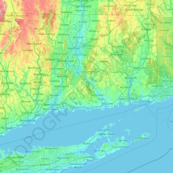
Название: Топографическая карта Middlesex, высота, рельеф.
Местонахождение: Middlesex, Connecticut, 06441, United States (40.75108 -73.25281 42.15108 -71.85281)
Средняя высота: 100 м
Минимальная высота: -3 м
Максимальная высота: 780 м
Сделать пожертвование
Другие топографические карты
Нажмите на карту, чтобы просмотреть ее топографию, ее высоту и ее рельеф.
Сделать пожертвование
Middletown
United States > Connecticut > Lower Connecticut River Valley Planning Region
Средняя высота: 76 м
Stratford
United States > Connecticut > Greater Bridgeport Planning Region
According to the United States Census Bureau, the town has a total area of 19.9 square miles (52 km2), of which 17.6 square miles (46 km2) is land and 2.3 square miles (6.0 km2), or 11.52%, is water. Stratford has a minimum elevation of zero feet above sea level along its coastline, with a maximum altitude of…
Средняя высота: 25 м
Сделать пожертвование
Redding
United States > Connecticut > Western Connecticut Planning Region
Redding's topography is dominated by three ridges, running north to south, with intervening valleys featuring steep slopes and rocky ledges in some sections. The highest elevation is about 830 feet above sea level, on Sunset Hill in the northeast part of the town; and the low elevation is about 290 feet above…
Средняя высота: 160 м
Сделать пожертвование
Glastonbury
United States > Connecticut > Capitol Planning Region
Glastonbury, Connecticut, features a diverse topography characterized by its location along the eastern banks of the Connecticut River, where the terrain begins at a low elevation near the river and gradually ascends into rolling hills. The town encompasses notable elevations such as Kongscut Mountain and…
Средняя высота: 67 м
Сделать пожертвование
Сделать пожертвование
Fairfield County
United States > Connecticut > Greater Bridgeport Planning Region
The terrain of the county trends from flat near the coast to hilly and higher near its northern extremity. The highest elevation is 1,290 feet (393 m) above sea level along the New York state line south of Branch Hill in the Town of Sherman; the lowest point is sea level itself.
Средняя высота: 115 м
Saybrook Manor
United States > Connecticut > Lower Connecticut River Valley Planning Region > Old Saybrook > Saybrook Manor
Средняя высота: 5 м
Сделать пожертвование
Сделать пожертвование
Killingworth Court
United States > Connecticut > South Central Connecticut Planning Region > New Haven
Средняя высота: 13 м
Сделать пожертвование
Hein Trails
United States > Connecticut > South Central Connecticut Planning Region > Bethany > Davidsons Corner
Средняя высота: 175 м
Austrailia Beach
United States > Connecticut > Southeastern Connecticut Planning Region > Mystic
Средняя высота: 19 м
Old Mystic
United States > Connecticut > Southeastern Connecticut Planning Region > Groton > Old Mystic
Средняя высота: 42 м
Сделать пожертвование
New Haven
United States > Connecticut > South Central Connecticut Planning Region
Средняя высота: 20 м
Storrs
United States > Connecticut > Capitol Planning Region > Mansfield > Storrs
Средняя высота: 165 м
Сделать пожертвование
Сделать пожертвование
Norwalk
United States > Connecticut > Western Connecticut Planning Region
Norwalk's topography is dominated by its coastline along Long Island Sound, the Norwalk River and its eastern and western banks, and the Norwalk Islands. The highest elevation is 315 feet (96 m) above sea level on the fairway of the 16th hole of the Silvermine Golf Course, and the low elevation is sea level on…
Средняя высота: 24 м
Old Saybrook
United States > Connecticut > Lower Connecticut River Valley Planning Region
Средняя высота: 11 м
Mad River
United States > Connecticut > Naugatuck Valley Planning Region > Waterbury > Fair Lawn
Средняя высота: 134 м
Сделать пожертвование
Austrailia Beach
United States > Connecticut > Southeastern Connecticut Planning Region > Mystic
Средняя высота: 19 м
New Haven
United States > Connecticut > South Central Connecticut Planning Region
Средняя высота: 20 м
Сделать пожертвование
Сделать пожертвование
Windham County
United States > Connecticut > Northeastern Connecticut Planning Region
Средняя высота: 155 м
New Haven County
United States > Connecticut > South Central Connecticut Planning Region
The terrain is mostly flat near the coast, with low hills defining the rest of the area, rising significantly only in the north of the county. The highest elevation is close to the northernmost point in the county, found at two areas of approximately 1,050 feet (320 m) above sea level in the town of Wolcott.…
Средняя высота: 87 м
Сделать пожертвование
Fairfield County
United States > Connecticut > Greater Bridgeport Planning Region
The terrain of the county trends from flat near the coast to hilly and higher near its northern extremity. The highest elevation is 1,290 feet (390 m) above sea level along the New York state line south of Branch Hill in the Town of Sherman; the lowest point is sea level itself.
Средняя высота: 108 м
Сделать пожертвование
Middletown
United States > Connecticut > Lower Connecticut River Valley Planning Region
Средняя высота: 76 м
New Haven
United States > Connecticut > South Central Connecticut Planning Region
Средняя высота: 20 м
Сделать пожертвование
Сделать пожертвование
Сделать пожертвование
West Hartford
United States > Connecticut > Capitol Planning Region
The west side of West Hartford is flanked by the Metacomet Ridge, a mountainous trap rock ridgeline that stretches from Long Island Sound to nearly the Vermont border. Notable features of the Metacomet Ridge in West Hartford include Talcott Mountain and a number of highland water reservoirs belonging to the…
Средняя высота: 60 м
Сделать пожертвование
Compo
United States > Connecticut > Western Connecticut Planning Region > Westport
Средняя высота: 10 м
Сделать пожертвование
Holcomb Farm
United States > Connecticut > Capitol Planning Region > Granby > West Granby
Средняя высота: 116 м
Chester
United States > Connecticut > Lower Connecticut River Valley Planning Region
Средняя высота: 62 м
Сделать пожертвование
Mystic
United States > Connecticut > Southeastern Connecticut Planning Region > Stonington > Mystic
Средняя высота: 15 м
Fairfield County
United States > Connecticut > Greater Bridgeport Planning Region
The terrain of the county trends from flat near the coast to hilly and higher near its northern extremity. The highest elevation is 1,290 feet (390 m) above sea level along the New York state line south of Branch Hill in the Town of Sherman; the lowest point is sea level itself.
Средняя высота: 108 м
Naugatuck State Forest
United States > Connecticut > Naugatuck Valley Planning Region > Beacon Falls
Средняя высота: 137 м
Highland Lake
United States > Connecticut > Northwest Hills Planning Region > Winchester
Средняя высота: 312 м
Сделать пожертвование
Weatogue
United States > Connecticut > Capitol Planning Region > Simsbury > Weatogue
Средняя высота: 80 м
Сделать пожертвование
North Haven
United States > Connecticut > South Central Connecticut Planning Region
Средняя высота: 38 м
Old Lyme
United States > Connecticut > Lower Connecticut River Valley Planning Region
Средняя высота: 19 м
Сделать пожертвование