
Топографическая карта Whittonstall
Нажмите на карту, чтобы отобразить высоту.
Об этой карте
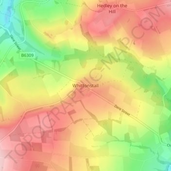
Название: Топографическая карта Whittonstall, высота, рельеф.
Местонахождение: Whittonstall, Northumberland, North East, England, DH8 9JN, United Kingdom (54.88966 -1.90859 54.92966 -1.86859)
Средняя высота: 181 м
Минимальная высота: 64 м
Максимальная высота: 277 м
Другие топографические карты
Нажмите на карту, чтобы просмотреть ее топографию, ее высоту и ее рельеф.
Holy Island of Lindisfarne
United Kingdom > England > Northumberland > Holy Island
Средняя высота: 1 м
Berwick-upon-Tweed
United Kingdom > England > Northumberland
In the 1840s, Samuel Lewis included similar entries for Berwick-upon-Tweed in both his England and Scotland Topographical Dictionary. Berwick remained a county in its own right, and remained a separate parliamentary constituency until 1885 when it was merged to become a division of Northumberland under the…
Средняя высота: 33 м
North Hazelrigg
United Kingdom > England > Northumberland > Chatton > North Hazelrigg
Средняя высота: 99 м
Catcleugh Reservoir
United Kingdom > England > Northumberland
Catcleugh Reservoir is a reservoir in Northumberland, England, adjacent to the A68 road just north of Byrness and to the southeast of the border with Scotland. It has a surface area of 98.654 ha and a mean depth of 9.8 m, a catchment area of 4007.5 ha, and is situated at 247 m altitude.
Средняя высота: 316 м