Геолокация

Топографическая карта Manganam

Интерактивная карта

Нажмите на карту, чтобы отобразить высоту.

Об этой карте

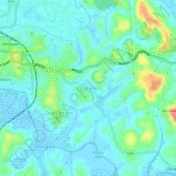
Название: Топографическая карта Manganam, высота, рельеф.

Местонахождение: Manganam, Kottayam, Kottayam District, Kerala, 686018, India (9.56334 76.52999 9.60334 76.56999)

Средняя высота: 16 м

Минимальная высота: -5 м

Максимальная высота: 73 м

Другие топографические карты

Нажмите на карту, чтобы просмотреть ее топографию, ее высоту и ее рельеф.

Pampady

India > Kerala > Kottayam

Pampady, Kottayam, Kottayam District, Kerala, 686502, India

Средняя высота: 55 м

Velloor

India > Kerala > Kottayam

Velloor, Kottayam, Kottayam District, Kerala, 686501, India

Средняя высота: 38 м

Meenadom

India > Kerala > Kottayam > Pariyaram

Meenadom, Pariyaram, Kottayam, Kottayam District, Kerala, 686021, India

Средняя высота: 36 м

Sankranthi

India > Kerala > Kottayam > Kottayam

Sankranthi, Kumaranalloor, Kottayam, Kerala, 686028, India

Средняя высота: 15 м

Kottayam

India > Kerala > Kottayam

Kottayam, Kottayam District, Kerala, 686001, India

Средняя высота: 19 м

Kumarakom

India > Kerala > Kottayam

Kumarakom, Kottayam, Kerala, 686563, India

Средняя высота: 2 м

Ettumanoor

India > Kerala > Kottayam

Ettumanoor, Kottayam, Kerala, 686631, India

Средняя высота: 22 м

Thiruvanchoor

India > Kerala > Kottayam > Thiruvanchoor

Thiruvanchoor, Kottayam, Kerala, 686032, India

Средняя высота: 11 м

Alapuzha

India > Kerala > Kottayam > Kottayam

Alapuzha, Devalokam, Kottayam, Kerala, India

Средняя высота: 10 м

Illickal Thazhe

India > Kerala > Kottayam > Kozhikombu > Illickal Thazhe

Illickal Thazhe, Kozhikombu, Kottayam, Kerala, 686635, India

Средняя высота: 46 м

Karapuzha

India > Kerala > Kottayam > Kottayam

Karapuzha, Kottayam, Kerala, India

Средняя высота: 7 м

Manarcadu

India > Kerala > Kottayam

Manarcadu, Kottayam, Kerala, 686019, India

Средняя высота: 23 м