
Топографическая карта West Arm Provincial Park
Интерактивная карта
Нажмите на карту, чтобы отобразить высоту.
Об этой карте
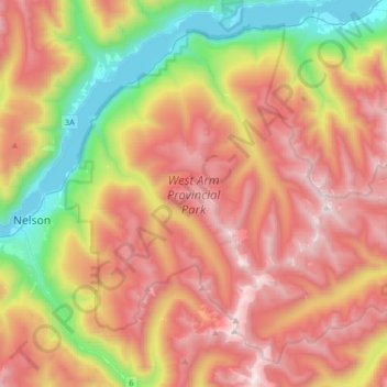
Название: Топографическая карта West Arm Provincial Park, высота, рельеф.
Средняя высота: 1 449 м
Минимальная высота: 526 м
Максимальная высота: 2 365 м
Другие топографические карты
Нажмите на карту, чтобы просмотреть ее топографию, ее высоту и ее рельеф.
Granite
Canada > British Columbia > Regional District of Central Kootenay > Area E (Balfour/Cottonwood Lake) > Blewett
Granite, Blewett, Area E (Balfour/Cottonwood Lake), Regional District of Central Kootenay, British Columbia, V1L 6X4, Canada
Средняя высота: 772 м
Ross-White Lady Lake Recreation Site
Canada > British Columbia > Regional District of Central Kootenay > Area E (Balfour/Cottonwood Lake)
Ross-White Lady Lake Recreation Site, Area E (Balfour/Cottonwood Lake), Regional District of Central Kootenay, British Columbia, Canada
Средняя высота: 1 858 м
Blewett
Canada > British Columbia > Regional District of Central Kootenay > Area E (Balfour/Cottonwood Lake) > Blewett
Blewett, Area E (Balfour/Cottonwood Lake), Regional District of Central Kootenay, British Columbia, V1L 6X4, Canada
Средняя высота: 837 м
Area E (Balfour/Cottonwood Lake)
Canada > British Columbia > Regional District of Central Kootenay > Area E (Balfour/Cottonwood Lake)
Area E (Balfour/Cottonwood Lake), Regional District of Central Kootenay, British Columbia, Canada
Средняя высота: 1 433 м
Kokanee Creek Provincial Park
Canada > British Columbia > Regional District of Central Kootenay > Area E (Balfour/Cottonwood Lake)
Kokanee Creek Provincial Park, Area E (Balfour/Cottonwood Lake), Regional District of Central Kootenay, British Columbia, Canada
Средняя высота: 617 м
Kokanee Creek
Canada > British Columbia > Regional District of Central Kootenay > Area E (Balfour/Cottonwood Lake)
Kokanee Creek, Area E (Balfour/Cottonwood Lake), Regional District of Central Kootenay, British Columbia, Canada
Средняя высота: 2 022 м
Balfour
Canada > British Columbia > Regional District of Central Kootenay > Area E (Balfour/Cottonwood Lake)
Balfour, Area E (Balfour/Cottonwood Lake), Regional District of Central Kootenay, British Columbia, V0G 1C0, Canada
Средняя высота: 673 м