Геолокация

Топографическая карта Redhill

Интерактивная карта

Нажмите на карту, чтобы отобразить высоту.

Об этой карте

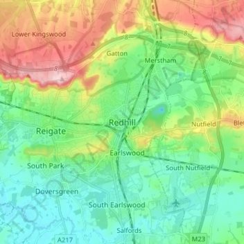
Название: Топографическая карта Redhill, высота, рельеф.

Местонахождение: Redhill, Reigate and Banstead, Surrey, England, RH1 1RJ, United Kingdom (51.20047 -0.20828 51.28047 -0.12828)

Средняя высота: 107 м

Минимальная высота: 47 м

Максимальная высота: 236 м

To the north, the town joins with the village of Merstham, north of which there is a "wind gap" in the chalk hills of the North Downs, at an elevation of 120 metres (390 ft) above sea level, through which the A23 road heads in from London. Geologists have speculated that there may once have been a consequent-flowing river, flowing northwards from the centre of the Weald-Artois Anticline and towards the River Thames, which originally cut both the Redhill Gap in the Greensand Ridge and the Merstham Gap in the chalk hills of the North Downs, before its waters were caught by subsequent streams of the River Mole (which itself cuts gaps northwards through the ridge at Betchworth, and through the Downs at Dorking, on its way to the Thames). Today the whole Redhill area is part of the catchment area of the River Mole, and hence the Thames.

Wikipedia (CC-BY-SA 3.0)

Другие топографические карты

Нажмите на карту, чтобы просмотреть ее топографию, ее высоту и ее рельеф.

Nork Park

United Kingdom > England > Surrey > Reigate and Banstead > Banstead

Nork Park, Nork, Banstead, Reigate and Banstead, Surrey, England, KT18 5XE, United Kingdom

Средняя высота: 143 м

Burgh Heath

United Kingdom > England > Surrey > Reigate and Banstead

Burgh Heath, Reigate and Banstead, Surrey, England, KT20 5NJ, United Kingdom

Средняя высота: 143 м

Banstead Wood

United Kingdom > England > Surrey > Reigate and Banstead > Chipstead

Banstead Wood, Chipstead, Reigate and Banstead, Surrey, England, United Kingdom

Средняя высота: 145 м

St John's

United Kingdom > England > Surrey > Reigate and Banstead > Redhill

St John's, Meadvale, Redhill, Reigate and Banstead, Surrey, England, RH1 6QD, United Kingdom

Средняя высота: 87 м

Reigate

United Kingdom > England > Surrey > Reigate and Banstead

Reigate, Reigate and Banstead, Surrey, England, RH2 0AA, United Kingdom

Средняя высота: 100 м

Redhill Common

United Kingdom > England > Surrey > Reigate and Banstead > Redhill

Redhill Common, Meadvale, Redhill, Reigate and Banstead, Surrey, England, United Kingdom

Средняя высота: 92 м

Lower Kingswood

United Kingdom > England > Surrey > Reigate and Banstead

Lower Kingswood, Reigate and Banstead, Surrey, England, KT20 7AA, United Kingdom

Средняя высота: 170 м

Banstead

United Kingdom > England > Surrey > Reigate and Banstead

Banstead, Reigate and Banstead, Surrey, England, United Kingdom

Средняя высота: 142 м

Netherne-on-the-Hill

United Kingdom > England > Surrey > Reigate and Banstead

Netherne-on-the-Hill, Reigate and Banstead, Surrey, England, CR5 1NZ, United Kingdom

Средняя высота: 153 м

Reigate Hill

United Kingdom > England > Surrey > Reigate and Banstead

Reigate Hill, Reigate and Banstead, Surrey, England, RH2 9RN, United Kingdom

Средняя высота: 157 м

Lower Earlswood Lake

United Kingdom > England > Surrey > Reigate and Banstead > Redhill

Lower Earlswood Lake, Meadvale, Redhill, Reigate and Banstead, Surrey, South East England, England, United Kingdom

Средняя высота: 75 м

Salfords

United Kingdom > England > Surrey > Reigate and Banstead

Salfords, Reigate and Banstead, Surrey, England, RH1 5DG, United Kingdom

Средняя высота: 64 м

Norwood Hill

United Kingdom > England > Surrey > Reigate and Banstead > Norwood Hill

Norwood Hill, Reigate and Banstead, Surrey, South East England, England, RH6 0ET, United Kingdom

Средняя высота: 71 м

Tadworth

United Kingdom > England > Surrey > Reigate and Banstead

Tadworth, Reigate and Banstead, Surrey, England, KT20 5SW, United Kingdom

Средняя высота: 159 м

Horley

United Kingdom > England > Surrey > Reigate and Banstead

Horley, Reigate and Banstead, Surrey, England, United Kingdom

Средняя высота: 58 м