
Сделать пожертвование
Топографическая карта Brumadinho
Нажмите на карту, чтобы отобразить высоту.
Сделать пожертвование
Brumadinho
Brumadinho (Brazilian Portuguese: [bɾumaˈdʒiɲu]) is a Brazilian municipality in the state of Minas Gerais. The city belongs to the Belo Horizonte metropolitan mesoregion and to the microregion of Belo Horizonte. Brumadinho is at an altitude of 880 m. In 2020 the population was 40,666. The municipality is on the Paraopeba River.
Сделать пожертвование
Об этой карте
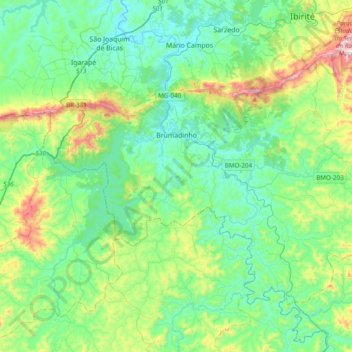
Название: Топографическая карта Brumadinho, высота, рельеф.
Средняя высота: 889 м
Минимальная высота: 710 м
Максимальная высота: 1 478 м
Сделать пожертвование
Другие топографические карты
Нажмите на карту, чтобы просмотреть ее топографию, ее высоту и ее рельеф.
Lagoa dos Ingleses
Brazil > Minas Gerais > Região Metropolitana de Belo Horizonte > Nova Lima
Средняя высота: 1 335 м
São Francisco de Assis
Brazil > Minas Gerais > Região Metropolitana de Belo Horizonte > Lagoa Santa
Средняя высота: 754 м
Belo Horizonte
Brazil > Minas Gerais > Região Metropolitana de Belo Horizonte
In 1893, due to the climatic and topographic conditions, Curral Del Rey was selected by Minas Gerais governor Afonso Pena among other cities as the location for the new economic and cultural center of the state, under the new name of Cidade de Minas, or City of Minas.
Средняя высота: 904 м
Contagem
Brazil > Minas Gerais > Região Metropolitana de Belo Horizonte > Contagem
The city belongs to the metropolitan mesoregion and to the microregion of Belo Horizonte, has a territorial extension of 195.2 square kilometres (75.4 square miles), and borders the municipalities of Ribeirão das Neves, Esmeraldas, Betim, Ibirité and Belo Horizonte. The elevation of the city hall is 939…
Средняя высота: 890 м
Сделать пожертвование
Pampulha
Brazil > Minas Gerais > Região Metropolitana de Belo Horizonte > Belo Horizonte > Pampulha
Средняя высота: 826 м
Itamarati
Brazil > Minas Gerais > Região Metropolitana de Belo Horizonte > Belo Horizonte
Средняя высота: 831 м