
Топографическая карта McKenzie River
Интерактивная карта
Нажмите на карту, чтобы отобразить высоту.
Об этой карте
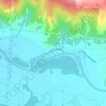
Название: Топографическая карта McKenzie River, высота, рельеф.
Местонахождение: McKenzie River, Lane County, Oregon, 97478, United States of America (44.06883 -122.91902 44.07077 -122.90958)
Средняя высота: 190 м
Минимальная высота: 143 м
Максимальная высота: 389 м
The McKenzie River drains a region of about 1,300 square miles (3,400 km2) and is one of the primary tributaries of the Willamette River. Elevations in the watershed range from 10,358 feet (3,157 m) at the summit of the South Sister to 375 feet (114 m) at the McKenzie's mouth on the Willamette River north of Eugene. The upper basin, in the high Cascades, consists of granular, permeable igneous rocks that are geologically young, while most of the middle and lower McKenzie valley in the Western Cascades is made of the remnants of older, more weathered volcanic rocks. Major watersheds bordering the McKenzie basin include the Calapooia; the South, Middle and North Santiam rivers to the north; the Middle Fork Willamette River to the south; and the Deschutes River to the east.
Другие топографические карты
Нажмите на карту, чтобы просмотреть ее топографию, ее высоту и ее рельеф.
Redmond
United States of America > Oregon > Redmond
Redmond, Deschutes County, Oregon, 97756, United States of America
Средняя высота: 919 м
Tualatin River
United States of America > Oregon
Tualatin River, Clackamas County, Oregon, 97068, United States of America
Средняя высота: 82 м
Forfar
United States of America > Oregon > Forfar
Forfar, Lincoln County, Oregon, United States of America
Средняя высота: 30 м
Wimer
United States of America > Oregon > Wimer
Wimer, Jackson County, Oregon, United States of America
Средняя высота: 417 м
Trask River
United States of America > Oregon
Trask River, Tillamook County, Oregon, 97141, United States of America
Средняя высота: 223 м
Springwater
United States of America > Oregon > Springwater
Springwater, Clackamas County, Oregon, 97023, United States of America
Средняя высота: 309 м
Millican
United States of America > Oregon > Millican
Millican, Deschutes County, Oregon, United States of America
Средняя высота: 1 337 м
Brickerville
United States of America > Oregon > Mapleton > Brickerville
Brickerville, Mapleton, Lane County, Oregon, 97453, United States of America
Средняя высота: 183 м
Tillamook Rock Light
United States of America > Oregon
Tillamook Rock Light, Tillamook Rock Lighthouse Trail, Clatsop County, Oregon, United States of America
Средняя высота: 0 м
Saum Creek
United States of America > Oregon
Saum Creek, Washington County, Oregon, 97062, United States of America
Средняя высота: 110 м
Oak Grove
United States of America > Oregon > Oak Grove
Oak Grove, Clackamas County, Oregon, 97268, United States of America
Средняя высота: 49 м
Pilot Rock
United States of America > Oregon > Pilot Rock
Pilot Rock, Umatilla County, Oregon, United States of America
Средняя высота: 527 м
Hail Creek
United States of America > Oregon
Hail Creek, Crook County, Oregon, United States of America
Средняя высота: 1 412 м
Thousand Springs
United States of America > Oregon
Thousand Springs, Thousand Springs Road, Jackson County, Oregon, United States of America
Средняя высота: 1 536 м
Saint Joseph
United States of America > Oregon > Saint Joseph
Saint Joseph, Yamhill County, Oregon, 97127, United States of America
Средняя высота: 44 м
Jones Creek
United States of America > Oregon
Jones Creek, Josephine County, Oregon, 97506, United States of America
Средняя высота: 333 м