
Сделать пожертвование
Топографическая карта Lagos
Нажмите на карту, чтобы отобразить высоту.
Сделать пожертвование
Об этой карте
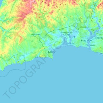
Название: Топографическая карта Lagos, высота, рельеф.
Местонахождение: Lagos, São Gonçalo de Lagos, Lagos, Faro, 8600-668, Portugal (36.94280 -8.83287 37.26280 -8.51287)
Средняя высота: 42 м
Минимальная высота: -5 м
Максимальная высота: 293 м
Сделать пожертвование
Другие топографические карты
Нажмите на карту, чтобы просмотреть ее топографию, ее высоту и ее рельеф.
Monchique
Monchique has a Mediterranean climate with warm to hot summers and mild, wet winters. Due to its altitude and location, right between the valley formed by the Serra de Monchique, precipitation in the winter is much larger than anywhere else on the Algarve. Its position on the southwest corner of Portugal gives…
Средняя высота: 206 м
Сделать пожертвование
Portimão
The geographical distribution of the altitude and relief of the municipality of Portimão generically follow the three types of territory present in the Barlavento: the coastal region, the Barrocal (a region between the coastal region and the mountains) and the mountains up north. Each one with their own…
Средняя высота: 67 м
Сделать пожертвование
Monchique
Monchique has a Mediterranean climate with warm to hot summers and mild, wet winters. Due to its altitude and location, right between the valley formed by the Serra de Monchique, precipitation in the winter is much larger than anywhere else on the Algarve. Its position on the southwest corner of Portugal gives…
Средняя высота: 206 м
Сделать пожертвование
Сделать пожертвование
Сделать пожертвование
Сделать пожертвование
Сделать пожертвование
Сделать пожертвование
Сделать пожертвование
Сделать пожертвование
Сделать пожертвование
Сделать пожертвование
Сделать пожертвование
São Brás de Alportel
During the 19th century the parish became an important economic center. Cork oak plantations encouraged commercial development and made São Brás de Alportel the largest cork producing center in Portugal. At the beginning of the 20th century (1912), São Brás de Alportel was the most populated parish in the…
Средняя высота: 322 м
Сделать пожертвование
Сделать пожертвование
Portimão
The geographical distribution of the altitude and relief of the municipality of Portimão generically follow the three types of territory present in the Barlavento: the coastal region, the Barrocal (a region between the coastal region and the mountains) and the mountains up north. Each one with their own…
Средняя высота: 67 м
Сделать пожертвование
Сделать пожертвование
Сделать пожертвование