
Сделать пожертвование
Топографическая карта Pullman
Нажмите на карту, чтобы отобразить высоту.
Сделать пожертвование
Pullman
The city is situated across several loess hills which characterize the Palouse Prairie, formed from windblown sediment over an estimated period of over one million years. This prairie region, the Palouse, is noteworthy for its fertile rolling hills where winter and spring wheat, barley, canola, lentils, and peas are grown. These hills provide a variety of elevations across the city, from 2342 to 2575 ft (714 to 785 m) above sea level. Downtown Pullman is situated in a valley between these hills. Within the Pullman city limits, the Missouri Flat Creek and Paradise Creek both join the South Fork of the Palouse River. Pullman sits in the watersheds of the Snake River and the Columbia River.
Сделать пожертвование
Об этой карте
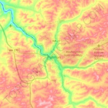
Название: Топографическая карта Pullman, высота, рельеф.
Местонахождение: Pullman, Whitman County, Washington, United States (46.70453 -117.22207 46.76195 -117.08557)
Средняя высота: 774 м
Минимальная высота: 688 м
Максимальная высота: 833 м
Сделать пожертвование
Другие топографические карты
Нажмите на карту, чтобы просмотреть ее топографию, ее высоту и ее рельеф.
Сделать пожертвование
Pullman
United States > Washington > Whitman County > Pullman > Pullman
The city is situated across several loess hills which characterize the Palouse Prairie, formed from windblown sediment over an estimated period of over one million years. This prairie region, the Palouse, is noteworthy for its fertile rolling hills where winter and spring wheat, barley, lentils, and peas are…
Средняя высота: 774 м
Сделать пожертвование