
Сделать пожертвование
Топографическая карта Buss's Corners
Нажмите на карту, чтобы отобразить высоту.
Сделать пожертвование
Об этой карте
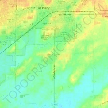
Название: Топографическая карта Buss's Corners, высота, рельеф.
Местонахождение: Buss's Corners, Town of Sun Prairie, Dane County, Wisconsin, 53590, United States (43.14611 -89.22734 43.18611 -89.18734)
Средняя высота: 289 м
Минимальная высота: 273 м
Максимальная высота: 305 м
Сделать пожертвование
Другие топографические карты
Нажмите на карту, чтобы просмотреть ее топографию, ее высоту и ее рельеф.
Madison
United States > Wisconsin > Dane County
The city is sometimes described as The City of Four Lakes, comprising the four successive lakes of the Yahara River: Lake Mendota ("Fourth Lake"), Lake Monona ("Third Lake"), Lake Waubesa ("Second Lake") and Lake Kegonsa ("First Lake"), although Waubesa and Kegonsa are not actually in Madison, but just south…
Средняя высота: 284 м
Сделать пожертвование
Mount Horeb
United States > Wisconsin > Dane County
Located in Southwest Wisconsin, Mount Horeb is situated in a region referred to as the Driftless Area. While including parts of eastern Minnesota, northeastern Iowa, and northwest Illinois, the Driftless Area is widely regarded as a distinct feature to the Wisconsin landscape, stretching across eighteen…
Средняя высота: 357 м
Сделать пожертвование
Сделать пожертвование
Сделать пожертвование
Сделать пожертвование
Sun Prairie
United States > Wisconsin > Dane County
The landscape of the city consists mostly of gently rolling hills and plains. The elevation of the city averages about 984 feet (300 m) above mean sea level.
Средняя высота: 293 м
Сделать пожертвование
Sun Prairie
United States > Wisconsin > Dane County
The landscape of the city consists mostly of gently rolling hills and plains. The elevation of the city averages about 984 feet (300 m) above mean sea level.
Средняя высота: 293 м
Сделать пожертвование
Mount Horeb
United States > Wisconsin > Dane County
Located in southwestern Wisconsin, Mount Horeb is situated in a region referred to as the Driftless Area. While including parts of southeastern Minnesota, northeastern Iowa, and northwestern Illinois, the Driftless Area is a distinct feature of the Wisconsin landscape, stretching across eighteen different…
Средняя высота: 357 м
Сделать пожертвование
Madison
United States > Wisconsin > Dane County
According to the United States Census Bureau, the city has a total area of 94.03 square miles (243.54 km2), of which 76.79 square miles (198.89 km2) is land and 17.24 square miles (44.65 km2) is water. The city's lowest elevation is the intersection of Regas Road and Corporate Drive on the east side, at 836.9…
Средняя высота: 284 м
Сделать пожертвование
Madison
United States > Wisconsin > Dane County
According to the United States Census Bureau, the city has an area of 94.03 square miles (243.54 km2), of which 76.79 square miles (198.89 km2) is land and 17.24 square miles (44.65 km2) is water. The city's lowest elevation is the intersection of Regas Road and Corporate Drive on the east side, at 836.9 ft…
Средняя высота: 284 м
Сделать пожертвование
Сделать пожертвование
Сделать пожертвование
Сделать пожертвование
Walking Iron County Park
United States > Wisconsin > Dane County > Town of Mazomanie
Средняя высота: 236 м
Goose Lake Wildlife Area
United States > Wisconsin > Dane County > Town of Deerfield
Средняя высота: 267 м
Сделать пожертвование
Madison
United States > Wisconsin > Dane County
According to the United States Census Bureau, the city has a total area of 94.03 square miles (243.54 km2), of which 76.79 square miles (198.89 km2) is land and 17.24 square miles (44.65 km2) is water. The city's lowest elevation is the intersection of Regas Road and Corporate Drive on the east side, at 836.9…
Средняя высота: 284 м
Сделать пожертвование
Madison
United States > Wisconsin > Dane County
According to the United States Census Bureau, the city has an area of 94.03 square miles (243.54 km2), of which 76.79 square miles (198.89 km2) is land and 17.24 square miles (44.65 km2) is water. The city's lowest elevation is the intersection of Regas Road and Corporate Drive on the east side, at 836.9 ft…
Средняя высота: 284 м
Сделать пожертвование
Сделать пожертвование
Сделать пожертвование