
Сделать пожертвование
Топографическая карта Pooyamkutty
Нажмите на карту, чтобы отобразить высоту.
Сделать пожертвование
Об этой карте
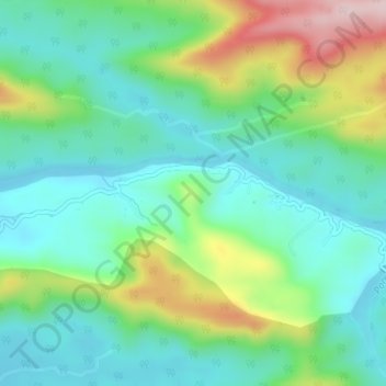
Название: Топографическая карта Pooyamkutty, высота, рельеф.
Местонахождение: Pooyamkutty, Kothamangalam, Ernakulam District, Kerala, India (10.16351 76.74943 10.17017 76.78710)
Средняя высота: 129 м
Минимальная высота: 35 м
Максимальная высота: 356 м
Сделать пожертвование
Другие топографические карты
Нажмите на карту, чтобы просмотреть ее топографию, ее высоту и ее рельеф.
Kothamangalam
India > Kerala > Kothamangalam
Kothamangalam is situated in the eastern part of the Ernakulam district. According to the division of the geographical regions of Kerala, Kothamangalam is in a mid-land region. The general topography is hilly.
Средняя высота: 34 м
Сделать пожертвование
Сделать пожертвование
Сделать пожертвование
Сделать пожертвование
Edamalakkudy
India > Kerala > Kothamangalam
Edamalakudy is located at an elevation of 1100–1700 metres, 22 km north-west of Pettimudi, a village about 4 km west of the Anamudi, the tallest mountain peak in South India on the border of Ernakulam district and Idukki district. Pettimudi was hit by a landslide in 2018 and the debris have not been cleared.…
Средняя высота: 1 095 м
Kothamangalam
India > Kerala > Kothamangalam
Kothamangalam is situated in the eastern part of the Ernakulam district. According to the division of the geographical regions of Kerala, Kothamangalam is in a mid-land region. The general topography is hilly.
Средняя высота: 34 м