
Сделать пожертвование
Топографическая карта Villa Kamboja
Нажмите на карту, чтобы отобразить высоту.
Сделать пожертвование
Об этой карте
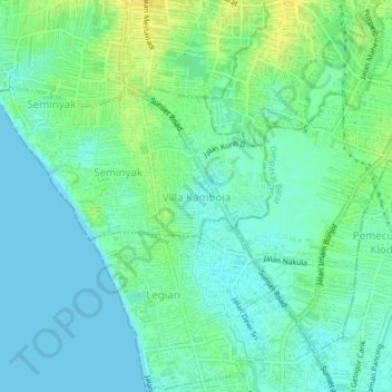
Название: Топографическая карта Villa Kamboja, высота, рельеф.
Местонахождение: Villa Kamboja, Seminyak, Kuta, Badung, Bali, Lesser Sunda Islands, 80261, Indonesia (-8.71328 115.15230 -8.67328 115.19230)
Средняя высота: 8 м
Минимальная высота: 0 м
Максимальная высота: 22 м
Сделать пожертвование
Другие топографические карты
Нажмите на карту, чтобы просмотреть ее топографию, ее высоту и ее рельеф.
Ayung River
The Ayung River watershed area has an annual average temperature between 18.4 °C and 26.6 °C, depending on the altitude. The average annual rainfall at the upstream is high, around 1963–3242 mm. Going downstream at an average inclination of 13.13%, the rainfall and the rainy days on the river decrease. In…
Средняя высота: 444 м
Сделать пожертвование
Pecatu
Pecatu is located in South Kuta District of the Badung Regency. It is at the western end of the Bukit Peninsula in south Bali, and has a hilly topography with limestone cliffs isolating small, short beaches that have been privately developed. Nusa Dua, on the opposite side of the peninsula, is flat and is a…
Средняя высота: 65 м